
Dear house building forum,
We are still quite early in the process. The planned development area in our municipality includes 9 building plots and is currently at an initial stage. A first draft from the urban planner has been submitted to the municipality. For illustration purposes, I have attached an amateur screenshot from the BayernAtlas.
I am hoping for feedback from more experienced eyes. We had to decide quite quickly, and all other plots are already reserved. So this is primarily about "our" plot and not about the possibilities of the others. I would like to thank you in advance for this.
To explain:
- In the northeast, the district road runs around the development area, which is a concrete street or dirt road.
- The access should either be via the district road or through the lower left corner. In both cases, we would have access through the centrally located cul-de-sac, without direct road connection, but possibly with a driveway (lower corner down to the cul-de-sac).
We have registered for the corner plot.
Reasons for this:
- All the plots attractive to us are on a slope; "our" plot is at the highest point.
- Access to nature from two sides.
About the plot itself:
- Plot size approximately 750 m2 (8,073 sq ft) as shown.
- Highest point top left (236.5 m (776 ft)), point bottom left (233.0 m (764 ft)), top right (232.5 m (763 ft)), (230.3 m (755 ft)).
The plot slopes diagonally by about 6 m (20 ft).
- On the screenshot, north is already at the top, so it should be a southeast-facing slope (?)
My questions:
1. How critical do you consider the slope, especially since it runs diagonally across the plot?
2. How would you position the house (without a building envelope/planning window at this stage, I know), considering the cardinal directions and the access (from the bottom right corner southward to the cul-de-sac)?
3. What have I forgotten to mention?
Thanks again in advance!
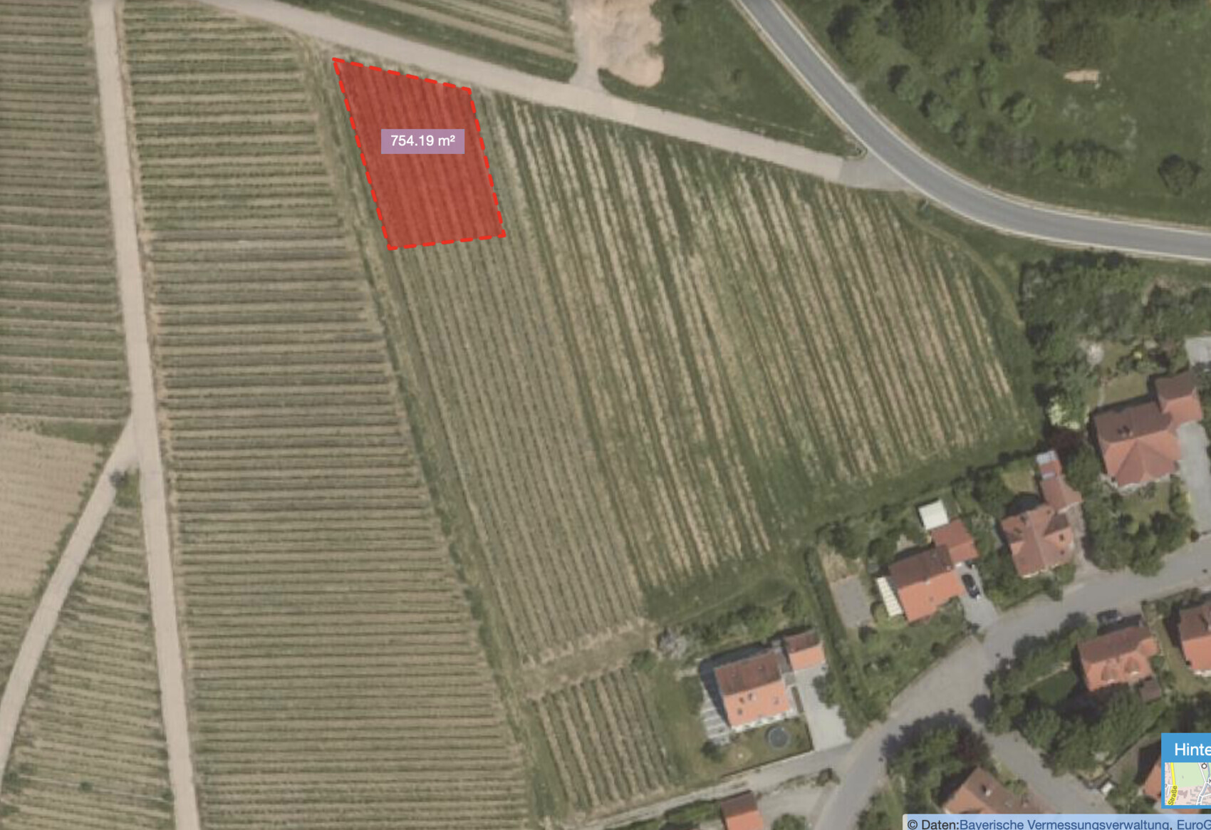
We are still quite early in the process. The planned development area in our municipality includes 9 building plots and is currently at an initial stage. A first draft from the urban planner has been submitted to the municipality. For illustration purposes, I have attached an amateur screenshot from the BayernAtlas.
I am hoping for feedback from more experienced eyes. We had to decide quite quickly, and all other plots are already reserved. So this is primarily about "our" plot and not about the possibilities of the others. I would like to thank you in advance for this.
To explain:
- In the northeast, the district road runs around the development area, which is a concrete street or dirt road.
- The access should either be via the district road or through the lower left corner. In both cases, we would have access through the centrally located cul-de-sac, without direct road connection, but possibly with a driveway (lower corner down to the cul-de-sac).
We have registered for the corner plot.
Reasons for this:
- All the plots attractive to us are on a slope; "our" plot is at the highest point.
- Access to nature from two sides.
About the plot itself:
- Plot size approximately 750 m2 (8,073 sq ft) as shown.
- Highest point top left (236.5 m (776 ft)), point bottom left (233.0 m (764 ft)), top right (232.5 m (763 ft)), (230.3 m (755 ft)).
The plot slopes diagonally by about 6 m (20 ft).
- On the screenshot, north is already at the top, so it should be a southeast-facing slope (?)
My questions:
1. How critical do you consider the slope, especially since it runs diagonally across the plot?
2. How would you position the house (without a building envelope/planning window at this stage, I know), considering the cardinal directions and the access (from the bottom right corner southward to the cul-de-sac)?
3. What have I forgotten to mention?
Thanks again in advance!
M
majuhenema30 Sep 2019 19:21First, I would like to thank everyone for the large number of helpful contributions! In this post, I will address the access situation, which is quite complicated, and in another post, I will ask a few questions.
In post #3, you can see Option A with access over the old town, a turning area, and the same exit. During the municipal council discussion, it was suggested that access could be arranged via a path (between plots 7 and 8). Here, the urban planner mentioned that there might be a long-distance water pipe (?) in that area, and it is legally not allowed to build over it. The council’s objection, that the turning area also covers the water pipe for 25m (82 feet), was dismissed with “Yes, but the road would be 35-40m (115-130 feet) long.” Does anyone know the legal situation regarding building over a long-distance water pipeline?
Option B runs along the county road. There is a sharp curve there (not visible on the sketch). This means a turning lane would be necessary. The county also wants a provision for road maintenance costs over the next 100 years. For these reasons, this option would be significantly more expensive.
ypg schrieb:
Realistically, I consider such access from a county road somewhat unrealistic or irresponsible. And until you know that, you can't make any plans.
In post #3, you can see Option A with access over the old town, a turning area, and the same exit. During the municipal council discussion, it was suggested that access could be arranged via a path (between plots 7 and 8). Here, the urban planner mentioned that there might be a long-distance water pipe (?) in that area, and it is legally not allowed to build over it. The council’s objection, that the turning area also covers the water pipe for 25m (82 feet), was dismissed with “Yes, but the road would be 35-40m (115-130 feet) long.” Does anyone know the legal situation regarding building over a long-distance water pipeline?
Option B runs along the county road. There is a sharp curve there (not visible on the sketch). This means a turning lane would be necessary. The county also wants a provision for road maintenance costs over the next 100 years. For these reasons, this option would be significantly more expensive.
M
majuhenema30 Sep 2019 19:41ypg schrieb:
The driveway is at the bottom right... you’re planning the garage at the top left... plus it’s higher elevation to the north, lower to the south... or did I misunderstand something?That’s exactly right. The access will only be possible via the cul-de-sac. The path behind our property is an agricultural road.
We would like to position the house as close to the driveway as possible. The reasons are:
1. To avoid wasting more square meters on the driveway.
2. The view is most attractive and unobstructed there.
3. Our current house has the garden arranged this way, and we find it a nice balance of sun and shade for outdoor sitting.
Our planned layout is:
Basement: garage, technical room, storage room
Ground floor: office, living, dining, kitchen, office
Upper floor: bedroom, bathroom, walk-in closet, 2 children’s rooms, children’s bathroom
I still don’t see the benefit of not putting the garage in the basement. In our case, building without a basement probably doesn’t make sense, and I don’t see the advantage of placing living areas in the basement while positioning the garage next to the house. Am I misunderstanding something here?
One more question: do you see any possibility on my green sketch to redesign our driveway? Given the high price per square meter and the ongoing costs, it’s quite frustrating. Could the urban planner not find a smarter solution? Maybe by rounding the property boundaries or something like that?
majuhenema schrieb:
Am I misunderstanding something here?Yes, a little Unfortunately, I don't have time to explain it right now.
M
majuhenema30 Sep 2019 19:54majuhenema schrieb:
In post #3 you can see Option A with access via the old town, a turning cul-de-sac, and the same exit. During the municipal council discussion, it was proposed that the entrance/exit could be made via a path (between plots 6 and 7). The urban planner mentioned that there is a long-distance water pipeline (?) there, which legally must not be built over. When the council pointed out that the cul-de-sac also covers the water pipeline for 25m (82 feet), the planner responded, "Yes, but the street would be 35–40m (115–131 feet) long." Does anyone have knowledge about the legal regulations regarding building over a long-distance water pipeline?Sorry, I just noticed that I may have expressed myself unclearly here. The proposal was to enter the development area from the west via the marked street and exit via another street between plots 6 and 7 (or vice versa). Here, the urban planner raised the argument concerning the long-distance water pipeline.
What are your thoughts on this?
M
majuhenema30 Sep 2019 20:12Escroda schrieb:
Otherwise, I consider the questions premature given the current planning stage. A meaningful house design, including the positioning of the building on the plot, is only possible once the conditions of the development plan, infrastructure access, and elevation are clearly defined and binding. It seems the decision for a plot in this location has already been made. Or does the location of the building envelope still influence whether the reservation will be accepted? You are probably right. All these considerations are just that for now. And no, the reservation definitely remains because it is "the nicest plot," with no utility lines or anything running through it. The biggest drawback is the driveway from the cul-de-sac, for which I unfortunately cannot think of any alternative proposal to communicate to the municipality or the urban planner.
majuhenema schrieb:
What do you think? Without the urban development plan, I don’t see anything. Discussing all the planning considerations here on the marketplace, taking local conditions into account, seems impossible to me.
The proposed alternatives don’t change the fact that your plot cannot be accessed from the north.
majuhenema schrieb:
because it is "the most beautiful plot" ...unfortunately, I don’t see any room for negotiation for you. You will probably have to accept this. The municipality could have designated your access as a public traffic area (you can still raise this during the public display of the development plan). However, this would not only reduce your profit but also cause additional costs. Why should the community be harmed when there are enough builders who will accept the plot as is?
From the perspective of North Rhine-Westphalia (NRW), you are even somewhat lucky. Here, entire dead-end streets are often established on private building plots and burdened with pedestrian, vehicle, and utility rights. This means the whole neighborhood drives over your land, and if something breaks, there is trouble over who pays for it.
Similar topics