
Dear house building forum,
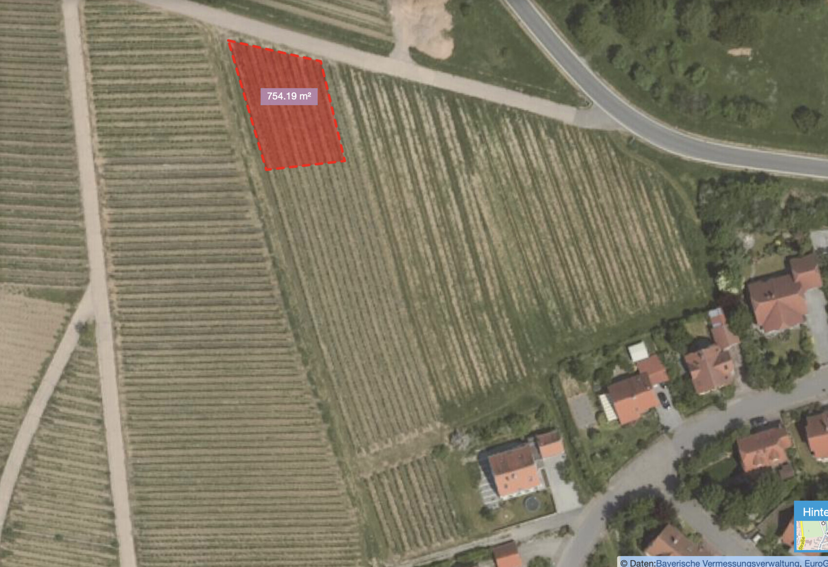
We are still quite early in the process. The planned development area in our municipality includes 9 building plots and is currently at an initial stage. A first draft from the urban planner has been submitted to the municipality. For illustration purposes, I have attached an amateur screenshot from the BayernAtlas.
I am hoping for feedback from more experienced eyes. We had to decide quite quickly, and all other plots are already reserved. So this is primarily about "our" plot and not about the possibilities of the others. I would like to thank you in advance for this.
To explain:
- In the northeast, the district road runs around the development area, which is a concrete street or dirt road.
- The access should either be via the district road or through the lower left corner. In both cases, we would have access through the centrally located cul-de-sac, without direct road connection, but possibly with a driveway (lower corner down to the cul-de-sac).
We have registered for the corner plot.
Reasons for this:
- All the plots attractive to us are on a slope; "our" plot is at the highest point.
- Access to nature from two sides.
About the plot itself:
- Plot size approximately 750 m2 (8,073 sq ft) as shown.
- Highest point top left (236.5 m (776 ft)), point bottom left (233.0 m (764 ft)), top right (232.5 m (763 ft)), (230.3 m (755 ft)).
The plot slopes diagonally by about 6 m (20 ft).
- On the screenshot, north is already at the top, so it should be a southeast-facing slope (?)
My questions:
1. How critical do you consider the slope, especially since it runs diagonally across the plot?
2. How would you position the house (without a building envelope/planning window at this stage, I know), considering the cardinal directions and the access (from the bottom right corner southward to the cul-de-sac)?
3. What have I forgotten to mention?
Thanks again in advance!
We are still quite early in the process. The planned development area in our municipality includes 9 building plots and is currently at an initial stage. A first draft from the urban planner has been submitted to the municipality. For illustration purposes, I have attached an amateur screenshot from the BayernAtlas.
I am hoping for feedback from more experienced eyes. We had to decide quite quickly, and all other plots are already reserved. So this is primarily about "our" plot and not about the possibilities of the others. I would like to thank you in advance for this.
To explain:
- In the northeast, the district road runs around the development area, which is a concrete street or dirt road.
- The access should either be via the district road or through the lower left corner. In both cases, we would have access through the centrally located cul-de-sac, without direct road connection, but possibly with a driveway (lower corner down to the cul-de-sac).
We have registered for the corner plot.
Reasons for this:
- All the plots attractive to us are on a slope; "our" plot is at the highest point.
- Access to nature from two sides.
About the plot itself:
- Plot size approximately 750 m2 (8,073 sq ft) as shown.
- Highest point top left (236.5 m (776 ft)), point bottom left (233.0 m (764 ft)), top right (232.5 m (763 ft)), (230.3 m (755 ft)).
The plot slopes diagonally by about 6 m (20 ft).
- On the screenshot, north is already at the top, so it should be a southeast-facing slope (?)
My questions:
1. How critical do you consider the slope, especially since it runs diagonally across the plot?
2. How would you position the house (without a building envelope/planning window at this stage, I know), considering the cardinal directions and the access (from the bottom right corner southward to the cul-de-sac)?
3. What have I forgotten to mention?
Thanks again in advance!
kaho674 schrieb:
At first glance, I would definitely try to access from the north. The garage should go in the northwest due to the angles.
The house could have a ground floor and a basement, plus possibly an attic.
[ATTACH alt="Erschließung.jpg"]38532[/ATTACH]
The question remains whether you are even allowed to do this, especially considering the location of the building plot. The lot doesn’t seem very wide, does it? The driveway is at the bottom right... you are planning the garage at the top left... also, the land slopes up in the north and down in the south... or did I misunderstand something?

kbt09 schrieb:
But there is supposed to be a road at the top as well. Yes, as far as I understood, access is also possible from the north. You can see the road. Or did I misunderstand that? If so, I would still check with the local authorities.
Additionally, it is located "at the top," overlooking your land down into the valley.
H
hampshire30 Sep 2019 18:20ypg schrieb:
Realistically, I find such an access from a roundabout somewhat unrealistic or negligent. And until you know this, you can’t make any plans.It depends on the speed limit there and how clear the area is. I wouldn’t be too concerned about that at first.kaho674 schrieb:
As far as I understood, access is also possible from the north The wording in the initial post is difficult to understand. However, it would be highly unusual if, in addition to the planned access via the turning area, there was also access through the service road. Informally, it might be helpful for garden design, but it is certainly not usable for accessing required parking spaces.
Otherwise, I consider the questions premature given the current stage of planning. Meaningful house planning, including the positioning of the building on the plot, is only possible once the conditions of the development plan, infrastructure connections, and elevation are sufficiently defined and binding. It seems the decision to choose a plot in this location has already been made. Or does the location of the building zone still affect whether the reservation will be accepted?
Similar topics