
Hello everyone,
we have a huge problem. We actually wanted to submit our building permit application in the next few days, but now everything is uncertain because of the garage.
Problem:
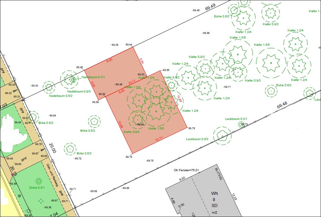
Please take a look at my excerpt from the site plan, it might help to better understand the situation. As you can see, our garage is planned to be built on the boundary. However, the elevation difference to the neighbor is about 10cm (4 inches). In the area of the garage, there is an elevation marker of 69.48m (228.1 ft). Our architect said this height would be sufficient and the garage could be properly planned. Anything lower would be difficult. Yesterday, we asked our surveyor to measure the corner points of the garage relative to the boundary, since these were missing from the plan. Now he has done this on the computer. Don’t ask me how. He somehow calculated a digital terrain model and got these results. Terrible, I can see the dream of having a garage fading away.
Why:
1) If we set the garage at 69.40m (228.0 ft), it will be significantly lower than the house. According to the current plan, the top of the finished floor slab is at 70.04m (229.7 ft). That would be a difference of about 60cm (2 feet)! That’s almost like an underground garage.
2) Looking at the other elevations, nearly the entire lot would have to be excavated. This would make the neighbor to the right much higher again, and retaining structures would be needed along almost the whole length. That would be very expensive.
3) Problems with the driveway: It is at an elevation of 69.67m to 69.70m (228.3 to 228.4 ft). This would mean I drive down into the garage. In heavy rain, I would have a small pool. In winter, with rain and below-freezing temperatures, I wouldn’t be able to get out of the garage because of the frozen ice on the ground. Also, the driveway slopes down immediately after the garage. The question is whether it would even be possible to drive back up onto the property if it slopes down right away. The driveway (owned by the municipality) actually goes slightly uphill. At the highest point the car might bottom out. Should we cut back the driveway? I don’t know if that would be allowed.
4) Transition garage–house: You are supposed to be able to go from the garage into the house. But with about a 60cm (2 feet) difference in height, this would probably cause problems with the door.
5) Lot design: How should we design the front yard if the garage slopes down so much? 🙁
Can you help us? This is so discouraging...
Are there any options to still save the garage? Or maybe an alternative? Maybe lower the house a bit? The top of the finished floor slab is at 69.70m (228.4 ft)? Then wouldn’t we avoid having to adjust for the 10cm (4 inches) difference to the neighbor on the right?
It’s all just awful. So much trouble already... Great.
Thanks a lot for your help.
we have a huge problem. We actually wanted to submit our building permit application in the next few days, but now everything is uncertain because of the garage.
Problem:
Please take a look at my excerpt from the site plan, it might help to better understand the situation. As you can see, our garage is planned to be built on the boundary. However, the elevation difference to the neighbor is about 10cm (4 inches). In the area of the garage, there is an elevation marker of 69.48m (228.1 ft). Our architect said this height would be sufficient and the garage could be properly planned. Anything lower would be difficult. Yesterday, we asked our surveyor to measure the corner points of the garage relative to the boundary, since these were missing from the plan. Now he has done this on the computer. Don’t ask me how. He somehow calculated a digital terrain model and got these results. Terrible, I can see the dream of having a garage fading away.
Why:
1) If we set the garage at 69.40m (228.0 ft), it will be significantly lower than the house. According to the current plan, the top of the finished floor slab is at 70.04m (229.7 ft). That would be a difference of about 60cm (2 feet)! That’s almost like an underground garage.
2) Looking at the other elevations, nearly the entire lot would have to be excavated. This would make the neighbor to the right much higher again, and retaining structures would be needed along almost the whole length. That would be very expensive.
3) Problems with the driveway: It is at an elevation of 69.67m to 69.70m (228.3 to 228.4 ft). This would mean I drive down into the garage. In heavy rain, I would have a small pool. In winter, with rain and below-freezing temperatures, I wouldn’t be able to get out of the garage because of the frozen ice on the ground. Also, the driveway slopes down immediately after the garage. The question is whether it would even be possible to drive back up onto the property if it slopes down right away. The driveway (owned by the municipality) actually goes slightly uphill. At the highest point the car might bottom out. Should we cut back the driveway? I don’t know if that would be allowed.
4) Transition garage–house: You are supposed to be able to go from the garage into the house. But with about a 60cm (2 feet) difference in height, this would probably cause problems with the door.
5) Lot design: How should we design the front yard if the garage slopes down so much? 🙁
Can you help us? This is so discouraging...
Are there any options to still save the garage? Or maybe an alternative? Maybe lower the house a bit? The top of the finished floor slab is at 69.70m (228.4 ft)? Then wouldn’t we avoid having to adjust for the 10cm (4 inches) difference to the neighbor on the right?
It’s all just awful. So much trouble already... Great.
Thanks a lot for your help.

Oops, I misread that—the numbers on the side are lengths, accidentally placed near the height values.
Alright, if we take the point where the garage meets the ground at the left front edge of the garage (69.40 / D) as the reference for the 3m (9 ft 10 in) height limit, I arrive at the following conclusion:

1) Top edge of garage finished floor at 69.70 (34 cm / 13 inches difference or 2 steps compared to 70.04 on the ground floor of the house)
2) Driveway level from B to C
3) Driveway rising 39 cm (15 inches) from A (69.31) to D
4) Garage height of 3.00 m (9 ft 10 in) minus reference point (69.40) subtracted from top edge of finished garage floor (69.70) results in a total garage structure height of 2.70 m (8 ft 10 in) above finished garage floor level
5) Parapet / ceiling structure of the garage estimated at 40 cm (16 inches) (you mentioned to ignore the fake gable), which gives a clear garage height of 2.30 m (7 ft 7 in). That should be enough for a Cayenne with a roof box without scratching, I’d say.
So, raise the driveway between C and D to the same height as B, and A can remain as is—you don’t have to make sure the car could balance a level on its roof while on the driveway.
https://www.instagram.com/11antgmxde/
https://www.linkedin.com/company/bauen-jetzt/
Alright, if we take the point where the garage meets the ground at the left front edge of the garage (69.40 / D) as the reference for the 3m (9 ft 10 in) height limit, I arrive at the following conclusion:
1) Top edge of garage finished floor at 69.70 (34 cm / 13 inches difference or 2 steps compared to 70.04 on the ground floor of the house)
2) Driveway level from B to C
3) Driveway rising 39 cm (15 inches) from A (69.31) to D
4) Garage height of 3.00 m (9 ft 10 in) minus reference point (69.40) subtracted from top edge of finished garage floor (69.70) results in a total garage structure height of 2.70 m (8 ft 10 in) above finished garage floor level
5) Parapet / ceiling structure of the garage estimated at 40 cm (16 inches) (you mentioned to ignore the fake gable), which gives a clear garage height of 2.30 m (7 ft 7 in). That should be enough for a Cayenne with a roof box without scratching, I’d say.
So, raise the driveway between C and D to the same height as B, and A can remain as is—you don’t have to make sure the car could balance a level on its roof while on the driveway.
https://www.instagram.com/11antgmxde/
https://www.linkedin.com/company/bauen-jetzt/
S
sauerpeter21 Mar 2017 11:46Hi,
a quick update to complete the picture. Our architect has now managed the height difference. Our garage is a bit lower in height – front top of the ring beam at 2.39 m (7 ft 10 in), roof surface intersection at 2.65 m (8 ft 8 in), and with the parapet at 3.03 m (10 ft) / rear top of the ring beam at 2.22 m (7 ft 3 in) and roof surface intersection at 2.48 m (8 ft 2 in) – but better than having no garage at all.
I’m curious to see how it will look in reality, since it is indeed somewhat lower in height compared to other garages. Obviously, the front parapet at 3.03 m (10 ft) helps visually, but the interior height is what really matters. Seeing that the rear top of the ring beam is at 2.22 m (7 ft 3 in) and a door height is 2.00 m (6 ft 7 in), it might feel quite cramped. But well... that’s complaining on a high level, the main thing is having a garage in the end.
You get used to everything.
a quick update to complete the picture. Our architect has now managed the height difference. Our garage is a bit lower in height – front top of the ring beam at 2.39 m (7 ft 10 in), roof surface intersection at 2.65 m (8 ft 8 in), and with the parapet at 3.03 m (10 ft) / rear top of the ring beam at 2.22 m (7 ft 3 in) and roof surface intersection at 2.48 m (8 ft 2 in) – but better than having no garage at all.
I’m curious to see how it will look in reality, since it is indeed somewhat lower in height compared to other garages. Obviously, the front parapet at 3.03 m (10 ft) helps visually, but the interior height is what really matters. Seeing that the rear top of the ring beam is at 2.22 m (7 ft 3 in) and a door height is 2.00 m (6 ft 7 in), it might feel quite cramped. But well... that’s complaining on a high level, the main thing is having a garage in the end.
You get used to everything.
11ant schrieb:
The states have geographic information systems. They contain so much terrain data that the surveyor doesn’t have to come out again every time. It’s not rocket science.This statement is complete nonsense.
Regards,
Dirk Grafe
S
sauerpeter21 Mar 2017 13:58Hello Dirk,
how do they do that then, or how do you do it? So somehow he must have calculated it on the computer. I just wonder how? Is an average determined? Or do you measure every few meters during the surveying process, which is not visible on the plan but can ultimately be extracted?
I would be interested to know. The surveyor told me that they run the recorded buildings through a terrain model and then calculate the heights at the corner points that way.
how do they do that then, or how do you do it? So somehow he must have calculated it on the computer. I just wonder how? Is an average determined? Or do you measure every few meters during the surveying process, which is not visible on the plan but can ultimately be extracted?
I would be interested to know. The surveyor told me that they run the recorded buildings through a terrain model and then calculate the heights at the corner points that way.
Yes, I can already imagine how this was done, but the raw data did not come from a publicly accessible geographic information system or similar source; rather, it was based on data collected independently. Obviously, previously measured elevations were used, and the area at the boundary, which was not originally captured during the first survey, was supplemented through blending/interpolation/extrapolation.
There is a residual risk, as the terrain may appear differently there, but this should have been noticed and recorded during the initial on-site survey.
However, this is ... very very very ... far from the claim that such data can be derived from geographic information systems with sufficient accuracy and reliability to omit the local survey.
Best regards
Dirk Grafe
There is a residual risk, as the terrain may appear differently there, but this should have been noticed and recorded during the initial on-site survey.
However, this is ... very very very ... far from the claim that such data can be derived from geographic information systems with sufficient accuracy and reliability to omit the local survey.
Best regards
Dirk Grafe
Dirk Grafe schrieb:
That is ... very very very far from the claim that such data can be derived from geographic information systems with sufficient accuracy and reliability, allowing one to skip on-site measurements.Haha, I wish that were true. No, I wasn’t referring to a complete scan of the world. Rather, many types of data (far from anything close to comprehensive) can already be found in digitized plans. Municipalities and utility companies use such information; what exists is used without measuring everything anew each time. Alternatively, a lot is interpolated, which naturally is only suitable for rough planning. Much of what I see in the plan shown here looks like such an approach, or, to put it kindly, the plots are just fallow land.
https://www.instagram.com/11antgmxde/
https://www.linkedin.com/company/bauen-jetzt/
Similar topics