
Hello everyone,
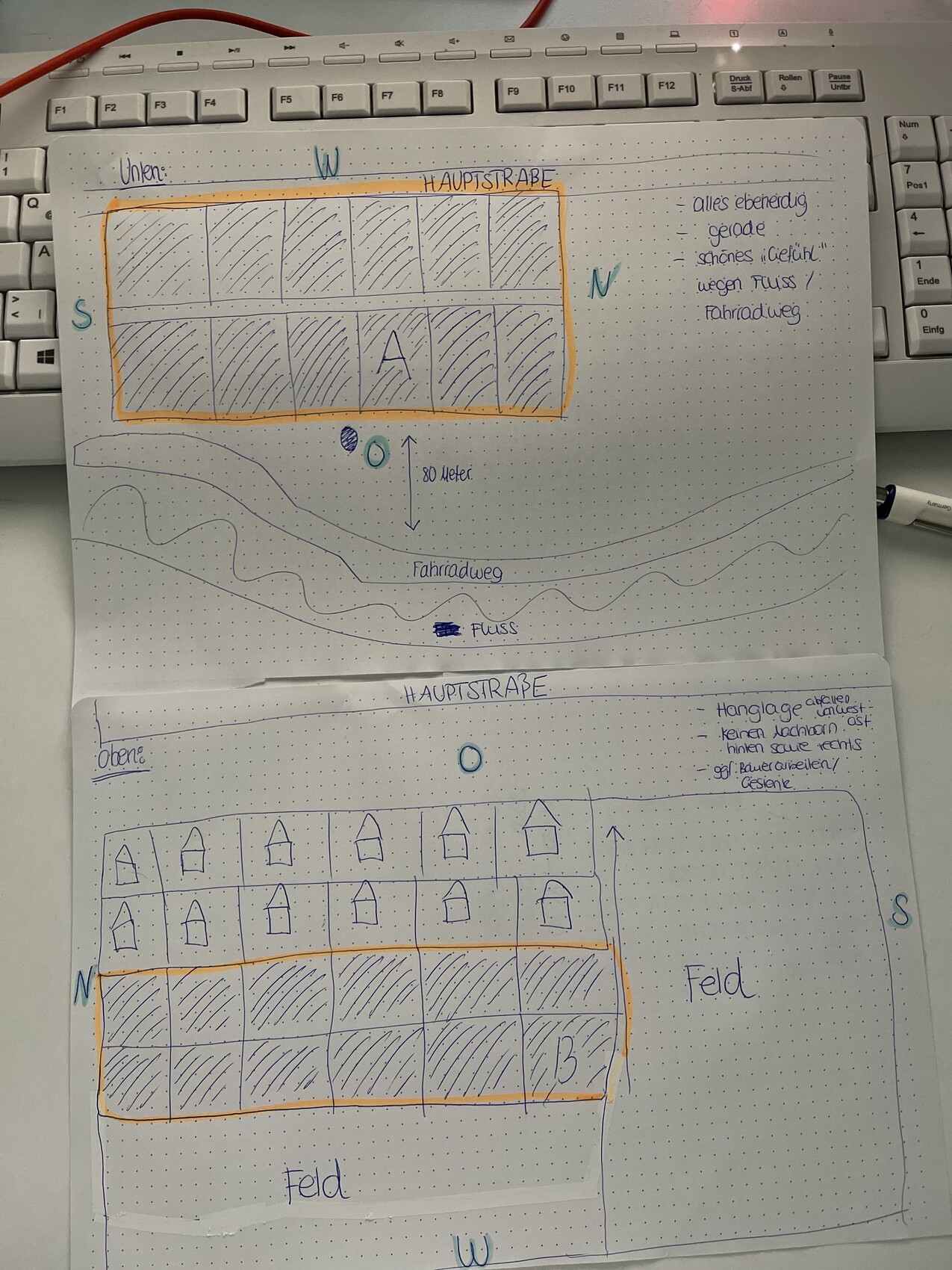
We are currently focusing heavily on searching for a plot of land. Two new residential areas are being developed nearby. I refer to them as "lower" and "upper" so you don’t get confused 😉
Plot A:
- quiet location
- all flat and level
- very nice atmosphere due to a small river and bike path
- generally lower price per square meter (sq m)
- neighbors on all sides (see image)
- uncertain regarding sunlight exposure and possible shading?
Plot B:
- slight slope (additional costs due to leveling, etc.)
- no neighbors at the back or on the right side
- unobstructed southwest-facing view
- possible odor / farming activities as we are right next to a field
- possibly higher price per square meter (sq m)
Both plots have pros and cons... we are really unsure. The lower plot has a very nice location since it is flat and quiet. The feeling is very pleasant. However, we are concerned about sunlight exposure, as we fear we might get little sun due to the neighboring houses. What do you think?
We are currently focusing heavily on searching for a plot of land. Two new residential areas are being developed nearby. I refer to them as "lower" and "upper" so you don’t get confused 😉
Plot A:
- quiet location
- all flat and level
- very nice atmosphere due to a small river and bike path
- generally lower price per square meter (sq m)
- neighbors on all sides (see image)
- uncertain regarding sunlight exposure and possible shading?
Plot B:
- slight slope (additional costs due to leveling, etc.)
- no neighbors at the back or on the right side
- unobstructed southwest-facing view
- possible odor / farming activities as we are right next to a field
- possibly higher price per square meter (sq m)
Both plots have pros and cons... we are really unsure. The lower plot has a very nice location since it is flat and quiet. The feeling is very pleasant. However, we are concerned about sunlight exposure, as we fear we might get little sun due to the neighboring houses. What do you think?
icandoit schrieb:
Clear statement: option B. How is it serviced/utilities connected?
What do you mean by slight slope? Please give some figures. 2 m (6.5 feet) across the property length?
You have the odor issue with option A as well.
Do you also have a building obligation with option B? Is there a developer involved? Nothing is connected yet. These are just the initial plans; as an interested party, you start thinking early because many will rush for the plots. We estimate the slight slope at a maximum of 3 m (10 feet).
Why do you lean towards option B? Best regards
Lenalele schrieb:
Nothing is developed yet. These are just the initial plans. As an interested party, you start thinking about it now because many people will rush for the plots. We estimate the gentle slope to be a maximum of 3 meters (10 feet).
Why are you leaning towards option B? Best regards Do you perhaps have photos of the plots? The dimensions of the plots can be measured from the geoportal or the zoning plan. That is accurate enough for us.
I like an unobstructed view and a true slope; however, 3 meters (10 feet) is not really a gentle slope. That probably means a basement is possible.
What can be seen to the east?
Are the plots not yet surveyed and developed?
Can you already buy them?
My first step is always to draw the plots to scale on graph paper. Then locate the access points according to the zoning plan. After that, draw in the north arrow and orient the plan to the north. North should be at the top.
Then add information about roof shape, roof pitch, wall heights, number of storeys, building lines and boundary development, etc. You can find all of this in the zoning plan.
Then you can start cutting out rough outlines of the house and garage or carport and start experimenting.
Lenalele schrieb:
We estimate a slight slope with a maximum of 3 meters (10 feet). That is quite a lot! The budget has to allow for that!
H
hampshire10 Mar 2021 12:53Lenalele schrieb:
We estimate a slight slope with a maximum of 3 meters (10 feet).Is the 3m (10 ft) height difference over what distance? Evenly distributed? How does it relate to the plot and the access road? You can get an idea using one of the geoportals and measure distances on your property.
For example, this is how it looks approximately on the left side from south (bottom) to north of our plot:
roughly along the centerline from south (bottom) to north
and similarly on the right side
This helps to visualize it.
You can measure in any direction, just draw lines.

In one of the examples, the building plots are arranged in rows of four, with two rows developed and two rows still free, if we trust your drawing (???)
https://www.instagram.com/11antgmxde/
https://www.linkedin.com/company/bauen-jetzt/
Lenalele schrieb:Please name it (without a link!, e.g. Posemuckel No. 234 "Am alten Sportplatz").
I exactly copied the zoning plan for the second design,
https://www.instagram.com/11antgmxde/
https://www.linkedin.com/company/bauen-jetzt/
Similar topics