
Hello everyone,
When I look at the plans from my surveyor and my architect, I notice the following details.
The top edge of the finished floor is specified as 70.65 m (232.0 ft).
The ground level of the plot is given as 70.50 m (233.3 ft).
The road surface elevation ranges between 70.36 m (230.9 ft) and 70.59 m (231.7 ft).
If I add the curb height (8 cm (3 inches)) to this, the planned road curb edge elevation is between 70.44 m (230.1 ft) and 70.67 m (231.9 ft).
As a layperson, I would assume that both the planned top edge of the finished floor and the plot ground level should be higher than this, right?
And the building permit/planning permission has already been granted.
Best regards,
Marko
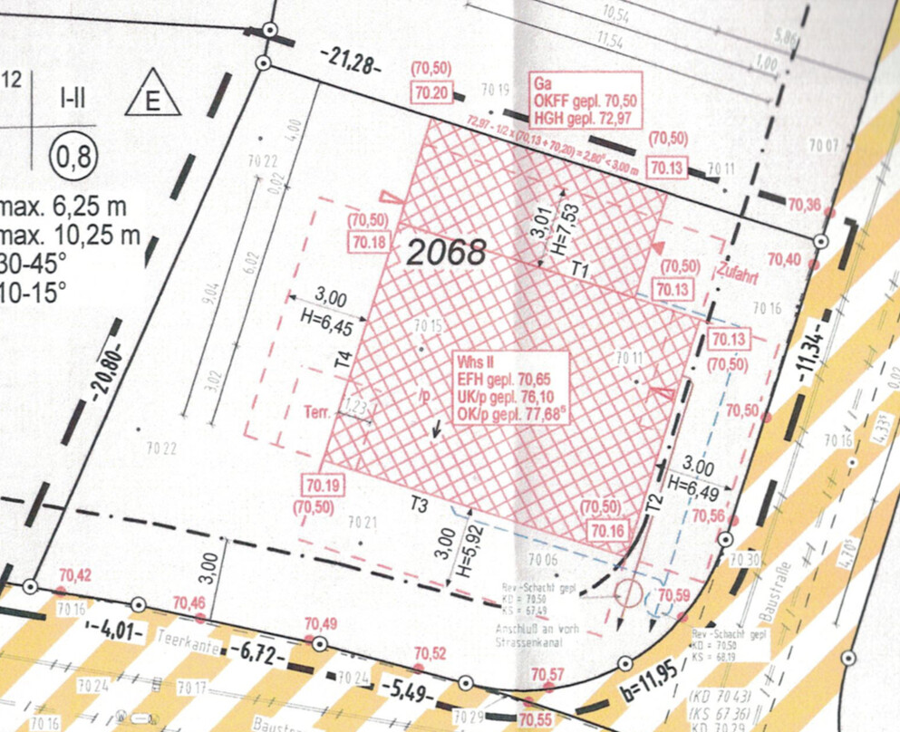
When I look at the plans from my surveyor and my architect, I notice the following details.
The top edge of the finished floor is specified as 70.65 m (232.0 ft).
The ground level of the plot is given as 70.50 m (233.3 ft).
The road surface elevation ranges between 70.36 m (230.9 ft) and 70.59 m (231.7 ft).
If I add the curb height (8 cm (3 inches)) to this, the planned road curb edge elevation is between 70.44 m (230.1 ft) and 70.67 m (231.9 ft).
As a layperson, I would assume that both the planned top edge of the finished floor and the plot ground level should be higher than this, right?
And the building permit/planning permission has already been granted.
Best regards,
Marko
Hello @bvlgari,
just to clarify regarding the attached plan from post #1:
Your surveyor has measured and indicated elevations on the plan. Usually, for your building permit / planning permission, elevations of the original terrain are measured at the boundary, but on the building plot itself. So it could be that these elevations reflect your ground level rather than the current construction road level. Or was the construction road already there at the time, actually reaching right up to your property? That is possible, but rather unlikely.
Another point I noticed – the plan appears to mix measured elevations for your lot and planned elevations for the (construction) road. This is not necessarily wrong or problematic, but the question remains whether the road was actually built as planned or if you should contact the municipality or the developer responsible for the final construction to ask what the finished road elevation (above sea level) will be. There should be more precise data on this by now.
In the best case, all of this may be completely fine.
Best regards
Dirk Grafe
just to clarify regarding the attached plan from post #1:
Your surveyor has measured and indicated elevations on the plan. Usually, for your building permit / planning permission, elevations of the original terrain are measured at the boundary, but on the building plot itself. So it could be that these elevations reflect your ground level rather than the current construction road level. Or was the construction road already there at the time, actually reaching right up to your property? That is possible, but rather unlikely.
Another point I noticed – the plan appears to mix measured elevations for your lot and planned elevations for the (construction) road. This is not necessarily wrong or problematic, but the question remains whether the road was actually built as planned or if you should contact the municipality or the developer responsible for the final construction to ask what the finished road elevation (above sea level) will be. There should be more precise data on this by now.
In the best case, all of this may be completely fine.
Best regards
Dirk Grafe
Dirk Grafe schrieb:
Hello @bvlgari,
just to clarify regarding your attached plan from post #1:
Your surveyor measured and indicated elevations on the plan. Usually, for your building permit / planning permission, elevations of the original terrain at the boundary, but on the building plot are measured. So, it could also be that these elevations reflect your ground level rather than the current construction road level. Or was the construction road already there at that time and did it really extend directly to your property? That is possible but rather unlikely.
Another point I noticed – the plan mixes obviously measured elevations for your property and planned elevations for the (construction) road. This is not necessarily a problem and not wrong, but it raises the question whether the road was built as planned or whether you should check with the city or the developer responsible for the final construction about the reference elevation (NHN) that the finished road will ultimately have. There should be more precise data available by now.
So, in the best case, all of this might be perfectly fine.
Regards,
Dirk GrafeHello Dirk,
I’m trying to answer your questions.
The construction road already existed at the time of the survey. The surveyor noted differences between the elevations he measured for the sewer and those from the city’s sewer as-built plan. He also recorded this on the site plan. I then contacted the city, and they confirmed in writing that this is acceptable, but we should follow the planned final construction elevations.
I have added a new image with more details visible.
B
Bauexperte13 Nov 2016 10:41Hello Marko,
I assume your architect used the weighted average of the elevations surrounding your property—70.50111 meters (231.14 feet)—and then added an entry step—70.65111 meters (239.70 feet).
It depends—and can be easily corrected by submitting an amendment to the building permit/planning permission—what the development plan or textual conditions specify regarding the height of the future floor slab. How many centimeters (inches) may the planned road elevation be exceeded by, and does this adjustment potentially conflict with the allowed eave or ridge height of your building project?
Regards, Bauexperte
bvlgari schrieb:That makes sense; after all, who wants to take the risk of water intrusion?
As a layperson, I would say that both the planned finished floor level and the land should be higher, right?
I assume your architect used the weighted average of the elevations surrounding your property—70.50111 meters (231.14 feet)—and then added an entry step—70.65111 meters (239.70 feet).
It depends—and can be easily corrected by submitting an amendment to the building permit/planning permission—what the development plan or textual conditions specify regarding the height of the future floor slab. How many centimeters (inches) may the planned road elevation be exceeded by, and does this adjustment potentially conflict with the allowed eave or ridge height of your building project?
Regards, Bauexperte
Bauexperte schrieb:
Hello Marko,
Logically; who wants to take the risk of water infiltration.
I assume your architect calculated the weighted average of the ground elevations surrounding your property => 70.50111 and added a step at the entrance => 70.65111
It depends—and can be easily corrected by an amendment to the building permit—on what the development plan or its textual supplements specify regarding the height of the future floor slab. How many centimeters above the planned street elevation is allowed, and does this adjustment possibly conflict with the permitted eaves height or ridge height of your building?
Regards, BauexperteHello Bauexperte,
Exactly, no one wants to take the risk of water infiltration, thank you for understanding me.
So, if I calculate an average of the street edge heights, I get the following calculation:
(70.50 + 70.54 + 70.57 + 70.60 + 70.65 (point in the curve, lower left) + 70.67 + 70.64 + 70.58 + 70.48) / 9 = 70.58
Is it possible that the architect used the street elevation as the boundary height for the property but didn’t include the curb height of 8 cm (3 inches)? Could he have forgotten that?
Regarding the eaves height or ridge height, that should not be the issue, as we still have some margin. The architect calculated a maximum eaves height of 77.04 and a maximum ridge height of 81.04. We are well below those limits, even though I think he also miscalculated the finished floor level of the ground floor.
bvlgari schrieb:
Hello Dirk,
I’m trying to answer your questions.
The construction access road was already in place at the time of the survey. The surveyor noted discrepancies between the channel elevations he measured and those shown in the city’s sewer plan. He also recorded this on the site plan. I then contacted the city, and they confirmed in writing that this is acceptable, but we should follow the planned finished external elevations.
I have added a new image that shows more details.If I interpret the plan correctly, your site ground level is about 20-30cm (8-12 inches) higher than the construction access road. Obtain the measurements for the final road construction – keep in mind that the road surface usually slopes downward from the center (near the curb) towards the edges. The exact profile can be seen in the cross-section.
If this is a standard structure, I would say it’s tight to match the planned finished floor level exactly, or you may need to cut some soil to make the ground level with the curb edge.
If you have some flexibility in height, consider revising the building permit / planning permission application. This is a minor adjustment and will usually be approved as long as the eave and ridge heights remain within the allowed limits.
Best regards,
Dirk Grafe
Similar topics