Hello everyone,
When I look at the plans from my surveyor and my architect, I notice the following details.
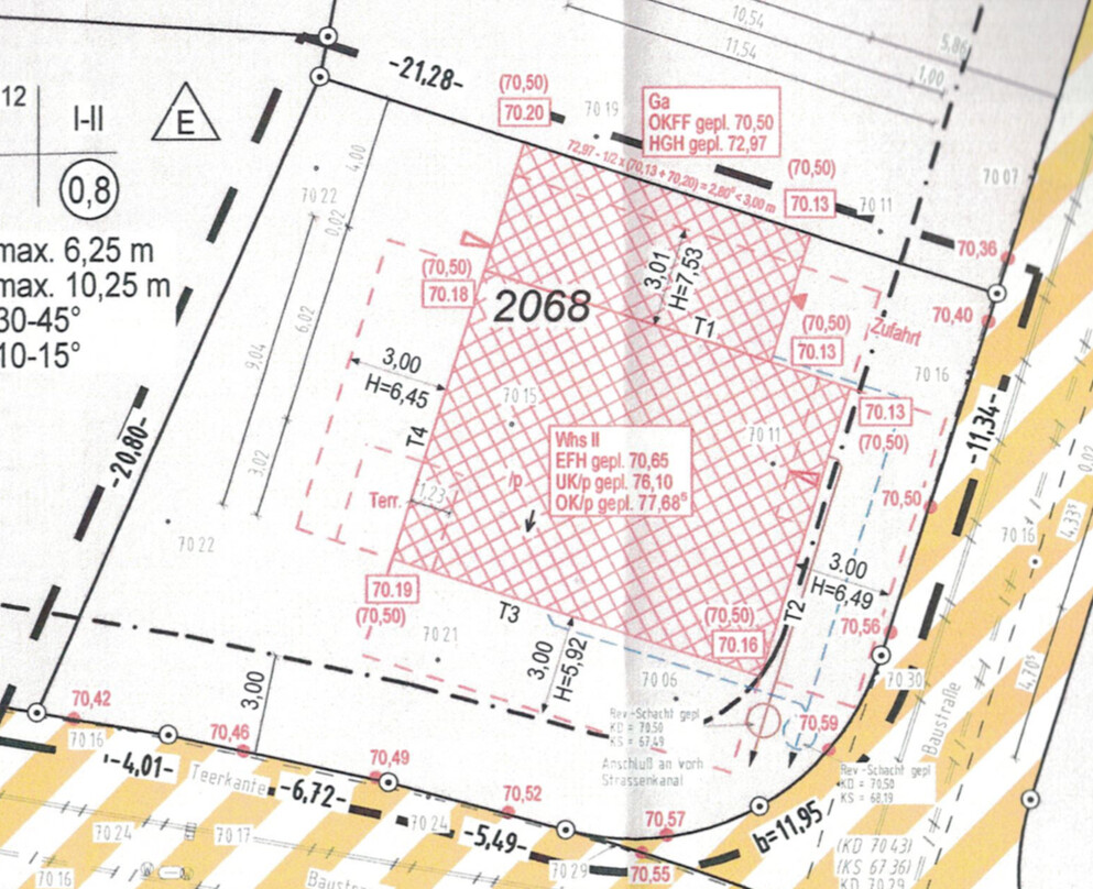
The top edge of the finished floor is specified as 70.65 m (232.0 ft).
The ground level of the plot is given as 70.50 m (233.3 ft).
The road surface elevation ranges between 70.36 m (230.9 ft) and 70.59 m (231.7 ft).
If I add the curb height (8 cm (3 inches)) to this, the planned road curb edge elevation is between 70.44 m (230.1 ft) and 70.67 m (231.9 ft).
As a layperson, I would assume that both the planned top edge of the finished floor and the plot ground level should be higher than this, right?
And the building permit/planning permission has already been granted.
Best regards,
Marko
When I look at the plans from my surveyor and my architect, I notice the following details.
The top edge of the finished floor is specified as 70.65 m (232.0 ft).
The ground level of the plot is given as 70.50 m (233.3 ft).
The road surface elevation ranges between 70.36 m (230.9 ft) and 70.59 m (231.7 ft).
If I add the curb height (8 cm (3 inches)) to this, the planned road curb edge elevation is between 70.44 m (230.1 ft) and 70.67 m (231.9 ft).
As a layperson, I would assume that both the planned top edge of the finished floor and the plot ground level should be higher than this, right?
And the building permit/planning permission has already been granted.
Best regards,
Marko
Dirk Grafe schrieb:
So if I interpret the plan correctly, your site (!) is about 20-30cm (8-12 inches) higher than the construction road. Get the exact measurements for the final road elevation – keep in mind that roads are usually higher in the middle (near the gutter line) and slope down towards the edges. You can see the exact profile in the cross-section.
If this is not a special construction, I would say your planned finished floor level might just work out, or you may need to remove some soil so that it matches the curb level on a flat plane.
However, if you have some flexibility, consider revising the building permit / planning permission accordingly. This is usually not a big issue and will be approved as long as the eaves and ridge heights still comply.
Best regards,
Dirk GrafeHello Dirk,
One of us must be misreading the plan. According to the architect, my site elevation should be 70.50. This means it is almost everywhere lower than the planned street edge height (road level plus 8cm (3 inches) for the curb):
70.50, 70.54, 70.57, 70.60, 70.65, 70.67, 70.64, 70.58, 70.48
Both.
For a rough staking, usually no elevation is given, or if a signal can be received, a GPS elevation is determined. This is accurate to about 3–5cm (1–2 inches) without a specific local reference point, which is sufficient for scraping or excavation. More effort is only made if it is suspected that accuracy down to the last centimeter on the building site is required. However, this is very rare.
For fine staking (or possibly even earlier, see above), more precise elevations are provided. There are several options:
1. Highest accuracy: transferring the elevation by leveling from an official benchmark; this is done during fine staking only if it is suspected or already known that the manhole cover register is inaccurate and every centimeter matters. Reasons for this can be a very slight slope available and/or fully utilized building heights/setback distances and a neighbor already threatening legal action.
2. Usually sufficient: the surveyor uses the manhole cover register and checks it by GPS measurement of the manhole covers (MC) and measurement of the corresponding invert depths. This reveals deviations in the fundamentally error-prone MC register or changes in the MC elevations. The inverts remain the same unless the entire sewer system is rebuilt. Both together, meaning the MC register and control measurement by GPS, do not claim absolute accuracy, but the relative elevation difference between the invert elevation where drainage enters and the elevation then specified by leveling in the staking plan (e.g., nail on the batter board, the batter board height itself, or similar) is available with high accuracy.
Case 2, to put it simply, only ensures that the water flows in the correct direction. If there are problems with the single-family house and/or ridge height and/or ground elevation/setback distances on cut or fill terrain, then this helps only to a limited extent.
I hope I have not overwhelmed you with this answer. If you have further questions, it makes little sense to continue in the forum. Feel free to contact me via private message or call the office; contact details are in the profile.
Best regards
Dirk Grafe
Similar topics