
ᐅ Layout of a Single-Family Home on a Small Trapezoidal Plot
Created on: 17 Jan 2024 21:21
Z
Zauberwald
Hello everyone,
I need your experience on the best way to position a house measuring 8.4 x 10.4 m (27.6 x 34.1 ft) on a trapezoidal plot of land to maximize usable garden space, while avoiding an excessively long driveway.
Development Plan/Restrictions
Plot size: 665 m² (7,157 sq ft)
Slope: slight, facing northwest
Floor area ratio: 2, no basement
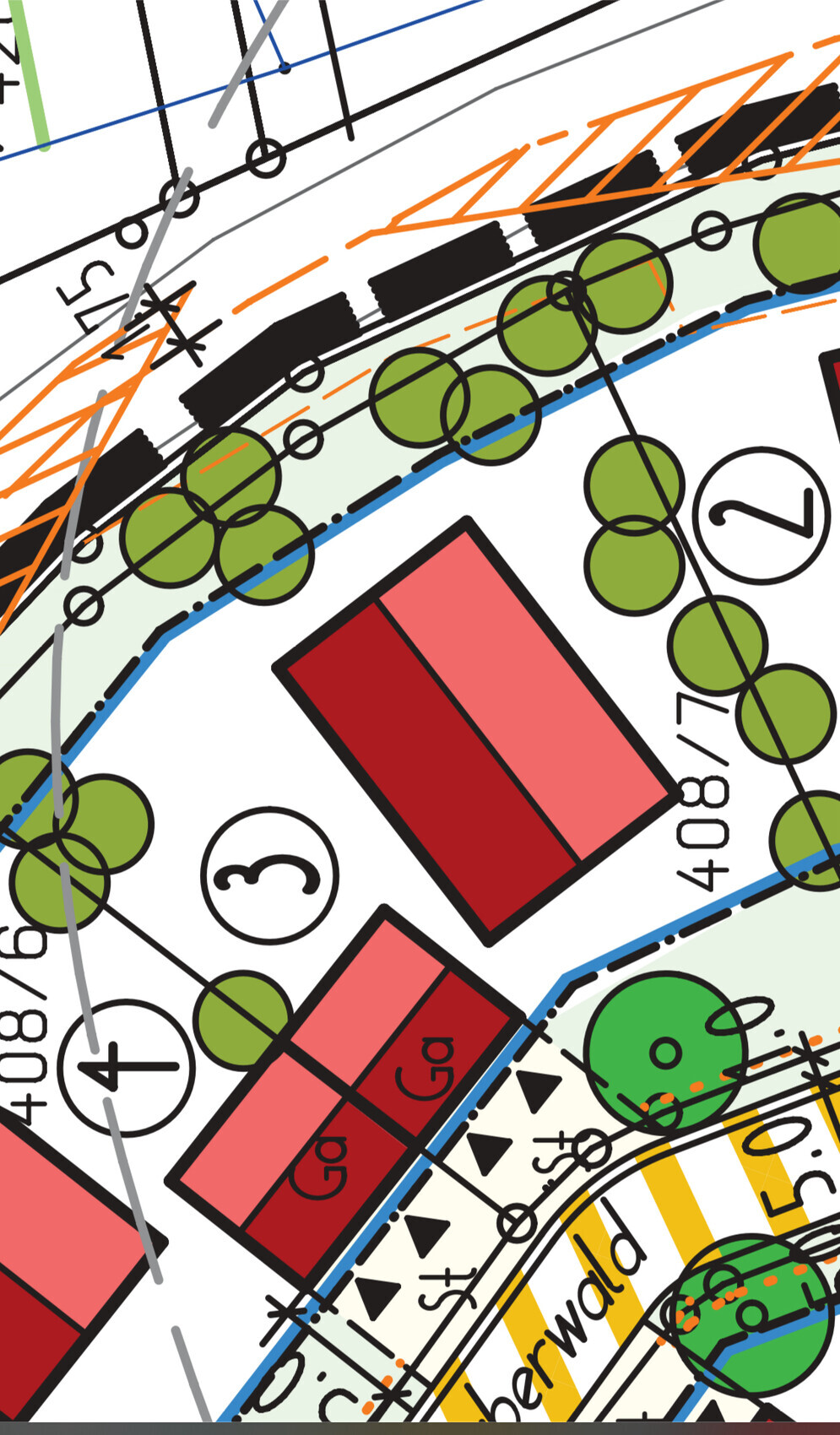
Building window, building line, and boundary: see plan
Building layout:
The longer upper side is about 30 m (98.4 ft) long
The shorter lower side is about 16 m (52.5 ft) long
The left side is 28 m (91.9 ft)
The right side is 30 m (98.4 ft)
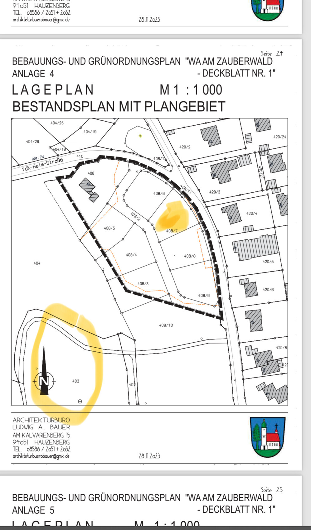
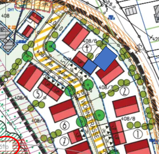
The plot is marked in yellow on the overview map, where the cardinal directions can also be seen.
The blue box marks the building window – it’s quite large. Roof ridge orientation does not matter. However, the setback distance of 3 m (9.8 ft) for the house must be respected. The garage and storage can be placed anywhere. The driveway access must be from the lower street.
Floor area ratio: 0.35
Edge development: no
Number of parking spaces: 2
Carport for 2 cars instead of a garage
Storage with 20 m² (215 sq ft)
Orientation: that’s the question!
I need your experience on the best way to position a house measuring 8.4 x 10.4 m (27.6 x 34.1 ft) on a trapezoidal plot of land to maximize usable garden space, while avoiding an excessively long driveway.
Development Plan/Restrictions
Plot size: 665 m² (7,157 sq ft)
Slope: slight, facing northwest
Floor area ratio: 2, no basement
Building window, building line, and boundary: see plan
Building layout:
The longer upper side is about 30 m (98.4 ft) long
The shorter lower side is about 16 m (52.5 ft) long
The left side is 28 m (91.9 ft)
The right side is 30 m (98.4 ft)
The plot is marked in yellow on the overview map, where the cardinal directions can also be seen.
The blue box marks the building window – it’s quite large. Roof ridge orientation does not matter. However, the setback distance of 3 m (9.8 ft) for the house must be respected. The garage and storage can be placed anywhere. The driveway access must be from the lower street.
Floor area ratio: 0.35
Edge development: no
Number of parking spaces: 2
Carport for 2 cars instead of a garage
Storage with 20 m² (215 sq ft)
Orientation: that’s the question!

Zauberwald schrieb:
The orange lines are only there to show the view toward the street. Two times no: I didn’t mean those (but the orange dashed lines in image 1, which unfortunately I cannot find explained in the legends of the Waldkirchen WA development plan at Zauberwald, 1st amendment), nor are these sight triangles. They are slopes for creating the road ditch to drain surface water from the "VdK-Heim-Straße". By the way, the original plan was to connect to this road; that has now been changed to the street "Am Zauberwald".
By the way, the development plan is not nearly as flexible as you described it so far, it even addresses roofs and their slopes in some detail and mentions hillside locations, although I haven’t found any elevation data yet. That would be highly relevant for the house orientation, since crossing the slope would make avoiding a basement more difficult. Your small section of the development plan is oriented east, north is at 270° (9 o’clock).
I’ll quote (in screenshots) some excerpts but couldn’t quickly find the house type that applies to you; depending on your individual slope position, you might be able to choose:
https://www.instagram.com/11antgmxde/
https://www.linkedin.com/company/bauen-jetzt/
H
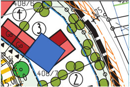
hanghaus202318 Jan 2024 14:01Was it not possible to make the plan section smaller? Even the property corners are missing. I took the liberty to orient the section to north.
Could you please mark the slope? Are there contour lines?
Could you please mark the slope? Are there contour lines?
hanghaus2023 schrieb:
Was it not possible to make the site plan section smaller? The corners of the property are missing. I took the liberty to orient the section to true north.
Could you also mark the slope? Are there any contour lines? I’m attaching a larger section (kept oriented to true north). I can’t find any elevation data, not even as survey points.
https://www.instagram.com/11antgmxde/
https://www.linkedin.com/company/bauen-jetzt/
Z
Zauberwald18 Jan 2024 14:57Hello, the ridge direction is not mandatory. The dimensions are only an indication of the approximate size. What we are interested in is the most practical orientation of the house to have a nice garden (whether you call it green space, shrubs, or something else). The orientation also naturally affects a potential future photovoltaic system. …
H
hanghaus202318 Jan 2024 14:5811ant schrieb:
I’m attaching a larger section (kept georeferenced), but I can’t find any elevation data, not even as survey points. I put on my glasses and marked the lines in red. The plan is oriented to true north.
A slope of 5 m (16 feet) over 65 m (213 feet) equals an 8% gradient towards the north.
H
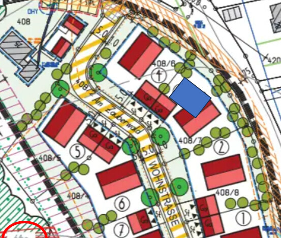
hanghaus202318 Jan 2024 15:11Here are two more options. I can’t think of anything better than an optimal photovoltaic system.
Similar topics