ᐅ Terracing with L-shaped retaining walls, overlapping of the steps
Created on: 17 Jul 2023 20:57
W
wp.seeker
Hello dear forum members,
We need to bridge a height difference of about 1.80 - 2.00 m (6 - 6.5 feet) from the terrace down to the garden. We will measure the exact height difference in the next few days.
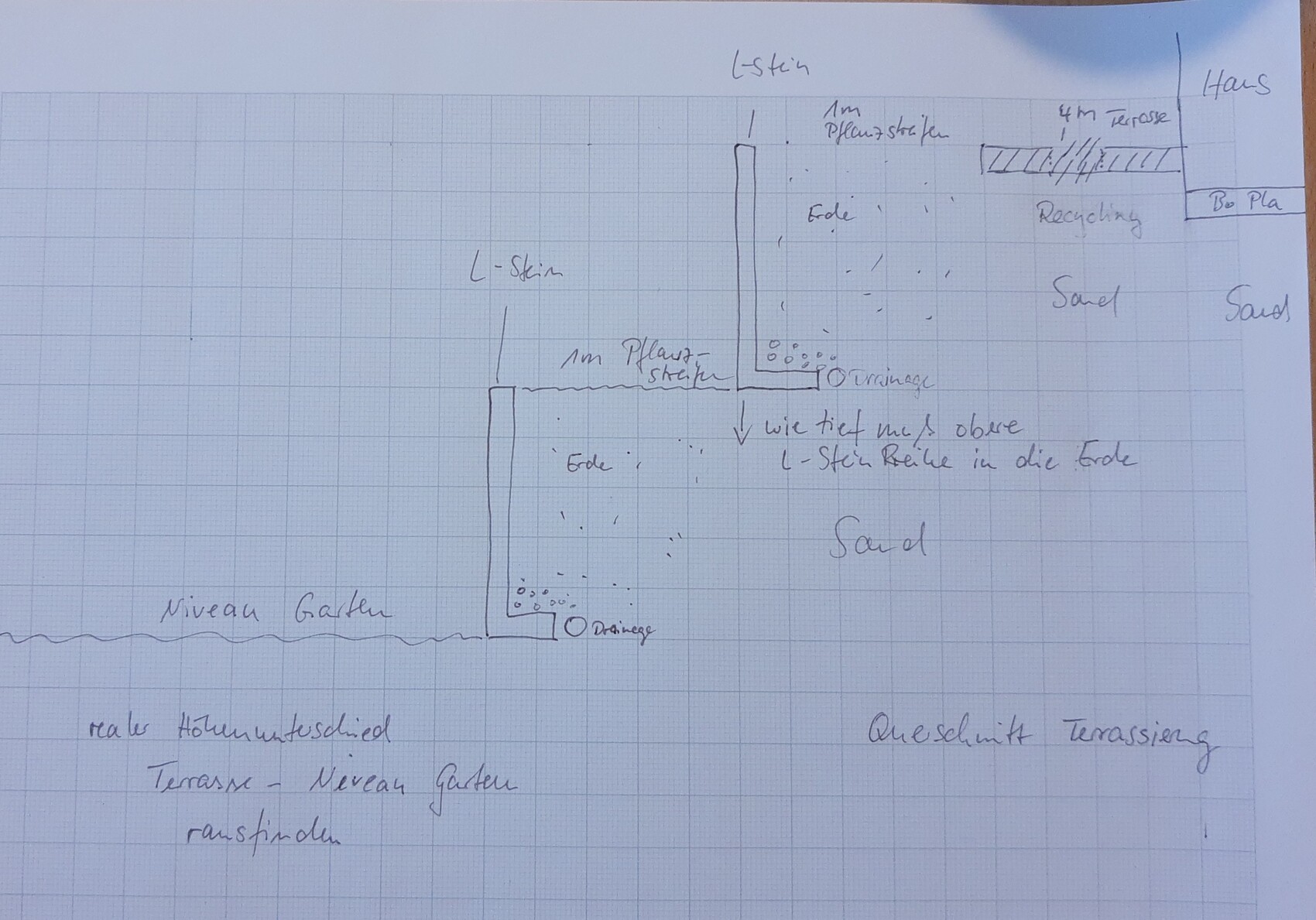
The plan is to build two steps using L-shaped retaining wall blocks. Starting from the house, there is a 4 m (13 feet) terrace, then a 1.00 m (3.3 feet) planting strip, followed by the first row of L-shaped blocks as a step. After that, another 1.00 m (3.3 feet) planting strip and then the second row of L-shaped blocks as the second step, which should bring us down to the garden level.
Here is an attempt at a sketch (cross-section).
Our questions:
How far below the ground level of the lower row does the top row of L-shaped blocks need to be founded? Is it sufficient if the foundation of the upper row is just below ground level?
Do you have any recommendations for reliable information sources on this topic?
If possible, after reviewing all the facts, we would like to do this ourselves, with the active support of a friend who has access to a suitably sized crane vehicle.
Thank you very much
We need to bridge a height difference of about 1.80 - 2.00 m (6 - 6.5 feet) from the terrace down to the garden. We will measure the exact height difference in the next few days.
The plan is to build two steps using L-shaped retaining wall blocks. Starting from the house, there is a 4 m (13 feet) terrace, then a 1.00 m (3.3 feet) planting strip, followed by the first row of L-shaped blocks as a step. After that, another 1.00 m (3.3 feet) planting strip and then the second row of L-shaped blocks as the second step, which should bring us down to the garden level.
Here is an attempt at a sketch (cross-section).
Our questions:
How far below the ground level of the lower row does the top row of L-shaped blocks need to be founded? Is it sufficient if the foundation of the upper row is just below ground level?
Do you have any recommendations for reliable information sources on this topic?
If possible, after reviewing all the facts, we would like to do this ourselves, with the active support of a friend who has access to a suitably sized crane vehicle.
Thank you very much

Thanks in advance for the responses.
I have indeed seen cascades from some manufacturers, but it’s unclear whether the inner row extends all the way to the bottom, starting at the same point as the outer row.
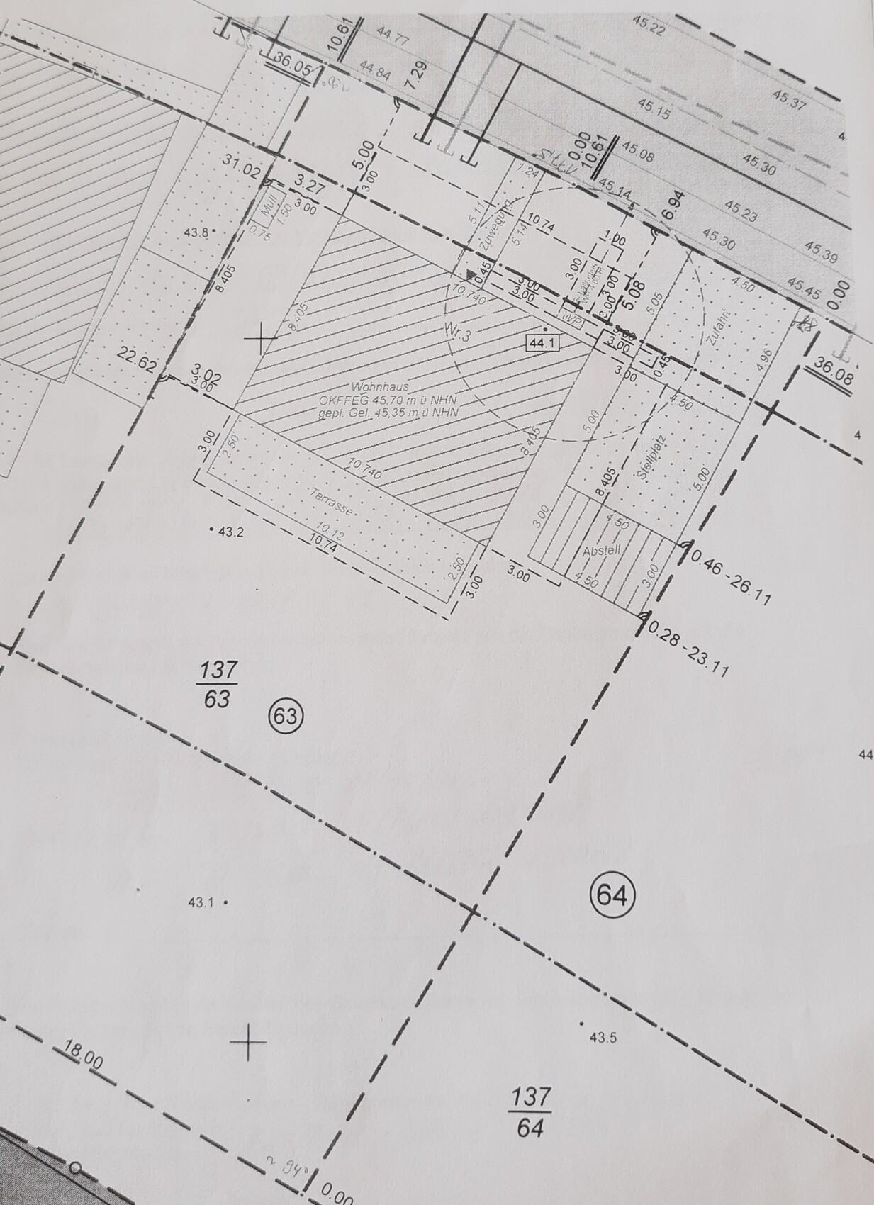
Attached is the site plan.
Ground level at the house: 45.35 m (149 ft)
Top edge of finished floor: 45.65 m (150 ft)
Top edge of finished terrace floor should be around 45.5 m (150 ft) (one step down from the terrace door)
The 43.2 m (142 ft) elevation point south of the terrace is no longer accurate, as we have filled the garden with our excavation material by about 50-80 cm (20-31 inches).
As mentioned, we will have to measure again soon.
Beneath the house and the planned terrace, the ground has been excavated and filled with compactable sand. Under the house about 100 cm (39 inches), under the planned terrace from natural level up to the current height, approximately 1.5-1.8 m (5-6 ft).
I am now looking for the soil report.
Thanks
I have indeed seen cascades from some manufacturers, but it’s unclear whether the inner row extends all the way to the bottom, starting at the same point as the outer row.
Attached is the site plan.
Ground level at the house: 45.35 m (149 ft)
Top edge of finished floor: 45.65 m (150 ft)
Top edge of finished terrace floor should be around 45.5 m (150 ft) (one step down from the terrace door)
The 43.2 m (142 ft) elevation point south of the terrace is no longer accurate, as we have filled the garden with our excavation material by about 50-80 cm (20-31 inches).
As mentioned, we will have to measure again soon.
Beneath the house and the planned terrace, the ground has been excavated and filled with compactable sand. Under the house about 100 cm (39 inches), under the planned terrace from natural level up to the current height, approximately 1.5-1.8 m (5-6 ft).
I am now looking for the soil report.
Thanks
Correction: The topsoil under the house has been replaced with 70-85 cm (28-33 inches) of fill, then additional material was added up to street level. In the south, the original elevation was 43.3 and 43.6 meters (142.0 and 143.0 feet) and raised to 45.3 meters NHN (148.6 feet). We also had sand added under the planned terrace, from the original elevation of 43.2 meters (141.7 feet) to 45.3 meters (148.6 feet).
So, almost everywhere there is at least 2 meters (6.6 feet) of sand.
So, almost everywhere there is at least 2 meters (6.6 feet) of sand.
H
hanghaus202319 Jul 2023 08:43Why was the house raised so high without a clear reason?
Am I correct in understanding that the street originally sloped quite steeply downwards, and then there was only a slight gradient afterward?
Am I correct in understanding that the street originally sloped quite steeply downwards, and then there was only a slight gradient afterward?
W
WilderSueden19 Jul 2023 08:53I don’t consider it that high. There is still 25cm (10 inches) available until reaching the maximum allowed height for a single-family house compared to the highest boundary point. The planned site level is about 4.35 meters (14 feet) roughly at the same height where the driveway meets the street. Many construction companies insist on building higher than the street level. I can understand that to some extent, so water drains away from the house.

In most residential zones (based on the development plans I have reviewed), retaining walls taller than 1 meter (3.3 feet) are not permitted. Before conducting a feasibility study, the key question should be: What is allowed here? Relevant regulations include the state building code, zoning plan (or planning permission), local neighborhood rules, and so on. This can sometimes be so complex that a layperson cannot find a fully satisfactory answer by simply searching online (meaning: consult a professional who understands the complete situation).
Previously, the building site was a potato field.
Our plot originally appeared relatively flat; only to the north or at our northern boundary did the hill start to rise more steeply (this is ground moraine terrain).
The road north of our property was then constructed at the natural level on its northern side, which made that area quite steep (from the perspective of a local). And suddenly, there was a sloping embankment from the road down onto our plot.
Exactly, @hanghaus2023
Then our developer wanted to build somewhat higher, as @WilderSueden suspected.
Which we basically approve of.
The development plan contains no restrictions regarding maximum building heights or terrain modeling. Next door, 1.50-meter (5-foot) retaining walls were installed, though that of course doesn’t mean much in this case.
I will look up the regional building code and neighbor law, thanks @i_b_n_a_n
Similar topics