_
_Jannika_26 Jul 2024 21:54Dear house building forum,
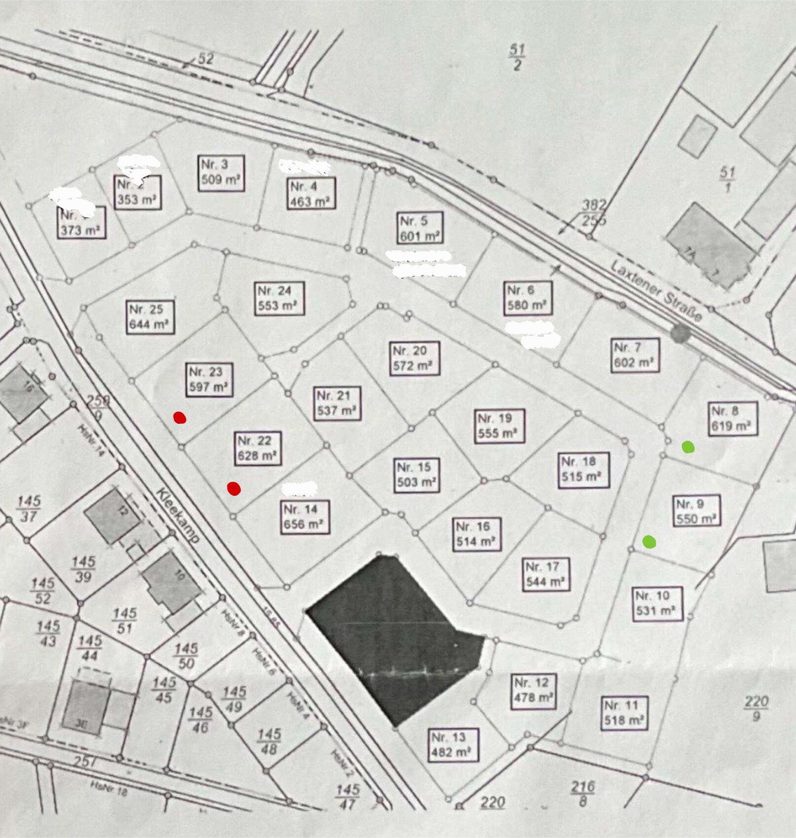
In our town, building plots in two residential areas were recently allocated simultaneously, which means that almost all plots in our preferred area are still available. These will be advertised again in the coming weeks, and we are now considering which plots would best suit our needs so that we have 2-3 favorites for the allocation. We have already given this some thought and are currently leaning towards plots no. 22 and 23, or alternatively no. 8 or 9. One current concern is whether the southwest orientation of the first-mentioned plots would make the terrace too hot in summer, as we have been hearing this more and more often from people we know. On the other hand, we would like to create a (small) vegetable garden with a greenhouse, so I thought a southern orientation might be advantageous.
Overall, we hope to receive suggestions and perspectives that we have not yet considered, so that we can make the best possible decision for us in the end.
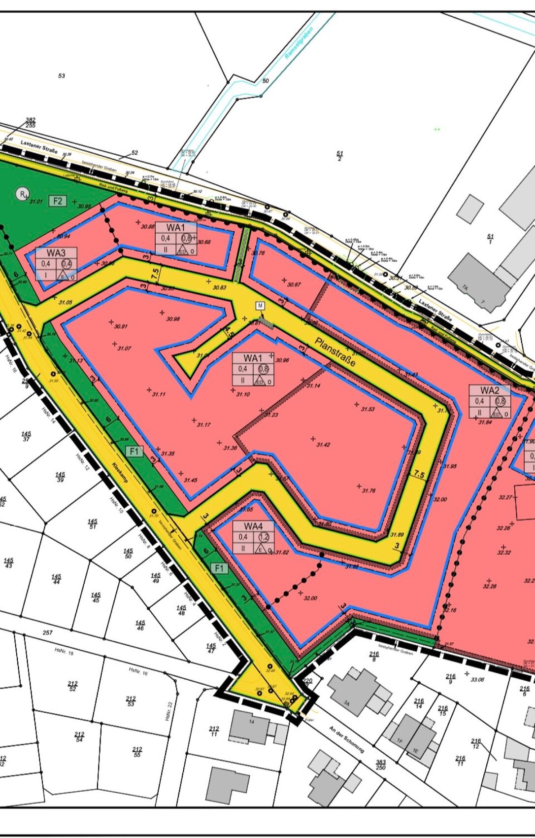
Development plan / restrictions:
Plot size: approx. 600 m² (6460 sq ft)
Slope: no
Floor area ratio (FAR): 0.4
Built-up area ratio (site coverage): 0.8
Edge development: no
Building boundary
Number of parking spaces: 2
Number of floors: 1.5
Roof type: gable roof
Style: modern
Maximum heights / limits: in WA1 the ridge height (TH) is 4.50 m (15 ft), in WA2 it is 6.50 m (21 ft); the overall building height (GH) is 10 m (33 ft) in both
--> current favorites marked with a red dot in WA1, green dot in WA2
Other requirements: roof pitch 35–45 degrees
We are also currently wondering how low the knee wall will be with a ridge height of 4.50 m (15 ft), and whether we might therefore tend towards WA2 and a two-story house instead.
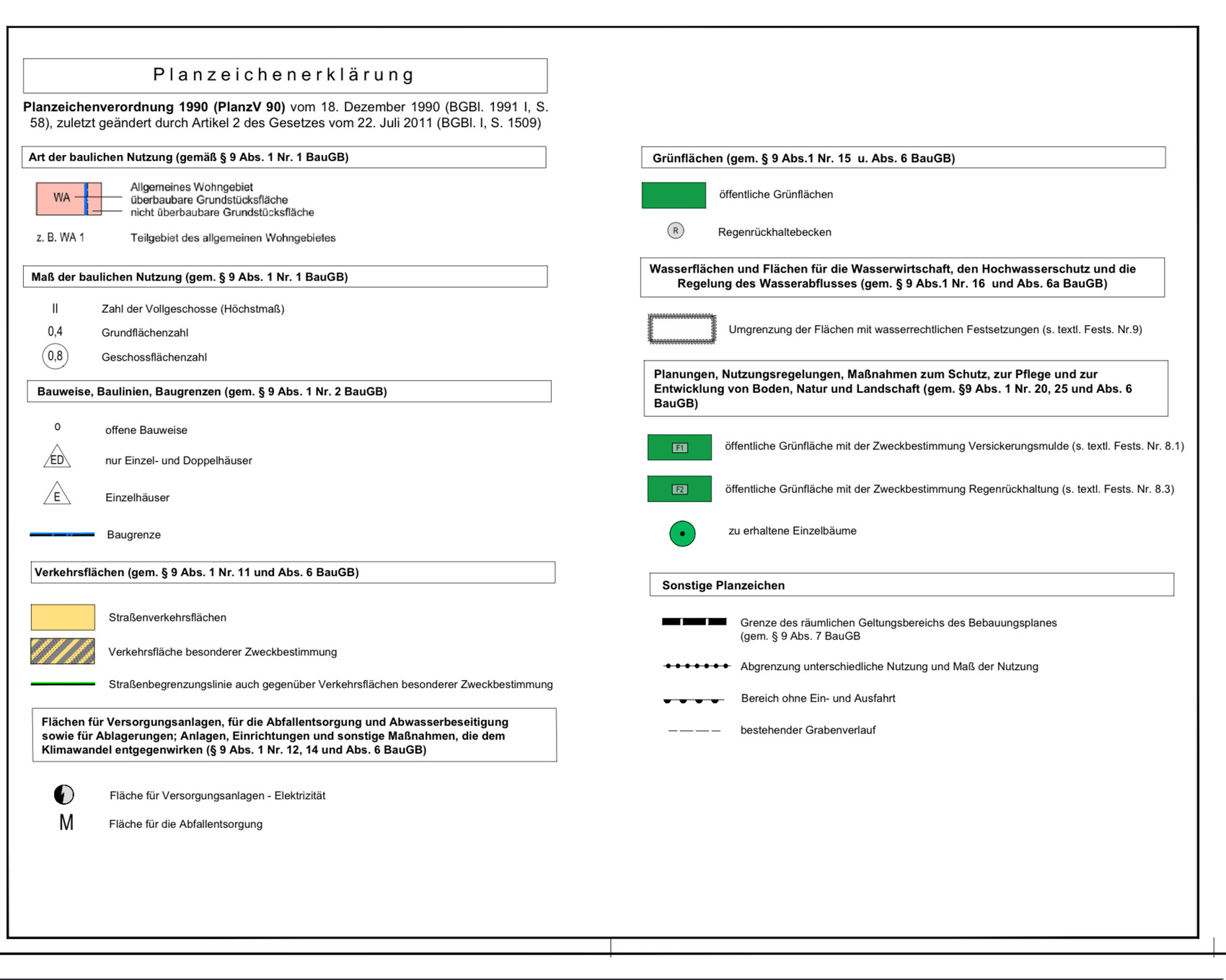
I apologize in advance for the plans, as I have seen much nicer versions posted here, and on my development plan the individual plots are not marked, but I hope that combining both plans makes the main information clear (don’t be surprised that I have removed personal data of already reserved plots from one of the overviews).
Thanks in advance for your input!
In our town, building plots in two residential areas were recently allocated simultaneously, which means that almost all plots in our preferred area are still available. These will be advertised again in the coming weeks, and we are now considering which plots would best suit our needs so that we have 2-3 favorites for the allocation. We have already given this some thought and are currently leaning towards plots no. 22 and 23, or alternatively no. 8 or 9. One current concern is whether the southwest orientation of the first-mentioned plots would make the terrace too hot in summer, as we have been hearing this more and more often from people we know. On the other hand, we would like to create a (small) vegetable garden with a greenhouse, so I thought a southern orientation might be advantageous.
Overall, we hope to receive suggestions and perspectives that we have not yet considered, so that we can make the best possible decision for us in the end.
Development plan / restrictions:
Plot size: approx. 600 m² (6460 sq ft)
Slope: no
Floor area ratio (FAR): 0.4
Built-up area ratio (site coverage): 0.8
Edge development: no
Building boundary
Number of parking spaces: 2
Number of floors: 1.5
Roof type: gable roof
Style: modern
Maximum heights / limits: in WA1 the ridge height (TH) is 4.50 m (15 ft), in WA2 it is 6.50 m (21 ft); the overall building height (GH) is 10 m (33 ft) in both
--> current favorites marked with a red dot in WA1, green dot in WA2
Other requirements: roof pitch 35–45 degrees
We are also currently wondering how low the knee wall will be with a ridge height of 4.50 m (15 ft), and whether we might therefore tend towards WA2 and a two-story house instead.
I apologize in advance for the plans, as I have seen much nicer versions posted here, and on my development plan the individual plots are not marked, but I hope that combining both plans makes the main information clear (don’t be surprised that I have removed personal data of already reserved plots from one of the overviews).
Thanks in advance for your input!
_
_Jannika_11 Oct 2024 12:08I would still appreciate any feedback. I believe that some information was missing or not clearly visible in the previous excerpts, so I would like to provide it here. If anything else is needed, please let me know.
North is at the top of the plan.
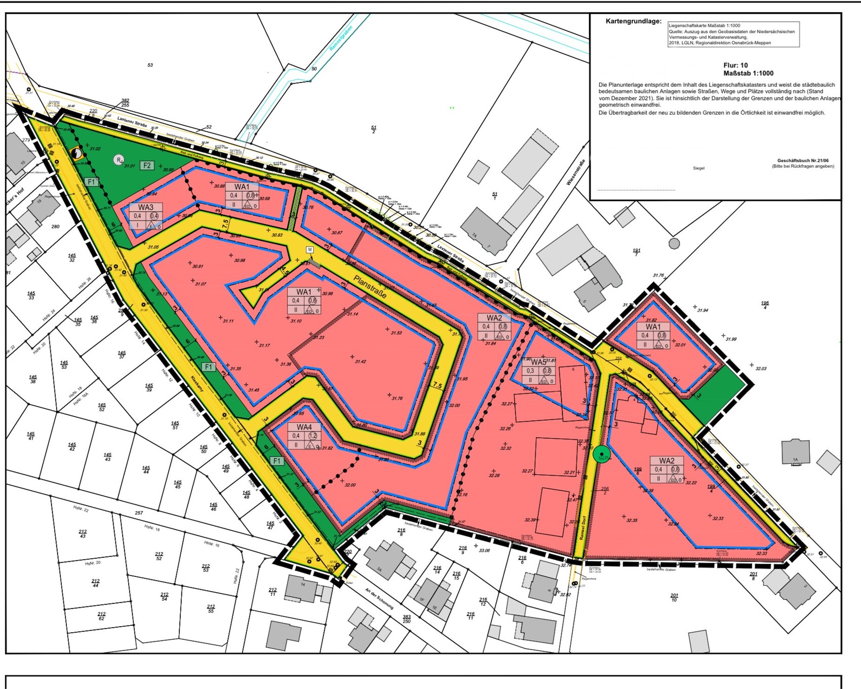
North is at the top of the plan.
H
hanghaus202311 Oct 2024 13:10My favorite is #9. The garage is on the north side, and there is no green space directly in front of the entrance.

_Jannika_ schrieb:
in WA1 the ridge height is 4.50 m (15 feet) and in WA2 it is 6.50 m (21 feet); the overall height for both is 10 m (33 feet) I don’t understand the difference in ridge heights, since the building site is almost flat. What are the water management specifics for the green-dotted plots?
https://www.instagram.com/11antgmxde/
https://www.linkedin.com/company/bauen-jetzt/
_
_Jannika_11 Oct 2024 15:5311ant schrieb:
I don’t understand the different TH levels; the building site is almost flat. What are the water law-related specifics of the green-pointed plots? Unfortunately, I also cannot say exactly what causes this. However, this is common in previous and other current development areas in our city. It seems as if this is intended to restrict or influence the construction of so-called urban villas. But this is just an amateur assumption.
Regarding area F1, the development plan states the following:
"The green space marked F1 is to be designed as an infiltration basin, and suitable locations must be planted with willows and black alders and maintained permanently."
Concerning the boundary of areas with water law regulations, it states:
"In the area of the outlined zones according to §9 Para. 1 No. 16d and Para. 6 of the Federal Building Code, water law requirements apply. In the marked area, stormwater on the building plots must infiltrate into vegetated surfaces or infiltration systems on the properties themselves. The technical guideline DWA-A 138 and information sheet DWA-M 153 must be observed."
_Jannika_ schrieb:
Unfortunately, I can’t say exactly what the cause is. However, this is normal in previous and other current development areas in our city... it seems as if the construction of so-called urban villas is intended to be restricted or influenced. But this is just an amateur guess. In a constitutional state, a layperson as a citizen does not have to guess but must be provided with a transparent basis for administrative acts. There must be a rationale for the zoning plan; such matters need to be addressed (in the "textual provisions" only THAT, but in the "rationale" also WHY). Otherwise, the zoning plan becomes legally vulnerable.
_Jannika_ schrieb:
Currently, we are also wondering how low the knee wall will be with a ridge height of 4.50 m (15 feet), and whether, depending on this, we should rather lean towards WA2 with a two-story house. Both eaves heights can be managed. But you must not be arbitrarily limited.
What an eaves height is practically “worth” largely depends on the reference height. Assuming a reasonable “zero,” then “+4.50” minus a floor height of about 2.85 m (9 feet 4 inches) results in a knee wall of 1.65 m (5 feet 5 inches). The knee wall essentially also separates window levels, so “favorable” knee walls are in the range of about 1.00 m (3 feet 3 inches) plus or minus 20 centimeters (8 inches). See also (externally) “How the Knee Wall Affects the Window Design in the Attic.”
https://www.instagram.com/11antgmxde/
https://www.linkedin.com/company/bauen-jetzt/
Similar topics