ᐅ How should these points be interpreted in the zoning plan (building plan)?
Created on: 8 Apr 2020 13:55
K
Katdreas
Hello,
maybe you can help me again this time. I have already spoken to the building authority, but the caseworker seemed to have a bad day and wasn’t very willing to explain things clearly—or maybe I’m just having trouble understanding...
We want to start planning our outdoor areas. We border three neighbors and a sidewalk.
Neighbor 1 is somewhat lower (40cm (16 inches)), neighbor 2 is a bit higher (70-80cm (27-31 inches)), neighbor 3 is significantly higher (120cm (47 inches) and more), and the sidewalk is lower (60cm (24 inches)).
Basically, anyone who excavates or fills in must stabilize the ground, right? But I guess that can be agreed on between the parties...
What I’m more concerned about now is what is actually allowed according to the development plan / building permit regulations.
As I understood the caseworker, you can do whatever you want within your own property, but then I don’t understand the rules about “raised terraces and steep slopes.” When exactly is a terrace considered raised, and when is a slope considered steep?
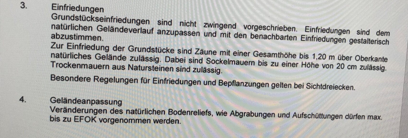
I was told that walls can only be 20cm (8 inches) high, and can be made of natural stone (but again, only 20cm high). When I read the relevant section in the development plan, I understand it as saying that base walls for fences can only be 20cm high, but natural stone walls are allowed??? How are you supposed to compensate for height differences then?
Fences can be a maximum of 120cm (47 inches) high from the top edge of the natural ground, right? Then neighbor 3 wouldn’t even be allowed to build a fence because the fill already exceeds 120cm.
By the way, the maximum finished ground floor level (finished floor level) was specified.
Thank you very much and Happy Easter!

maybe you can help me again this time. I have already spoken to the building authority, but the caseworker seemed to have a bad day and wasn’t very willing to explain things clearly—or maybe I’m just having trouble understanding...
We want to start planning our outdoor areas. We border three neighbors and a sidewalk.
Neighbor 1 is somewhat lower (40cm (16 inches)), neighbor 2 is a bit higher (70-80cm (27-31 inches)), neighbor 3 is significantly higher (120cm (47 inches) and more), and the sidewalk is lower (60cm (24 inches)).
Basically, anyone who excavates or fills in must stabilize the ground, right? But I guess that can be agreed on between the parties...
What I’m more concerned about now is what is actually allowed according to the development plan / building permit regulations.
As I understood the caseworker, you can do whatever you want within your own property, but then I don’t understand the rules about “raised terraces and steep slopes.” When exactly is a terrace considered raised, and when is a slope considered steep?
I was told that walls can only be 20cm (8 inches) high, and can be made of natural stone (but again, only 20cm high). When I read the relevant section in the development plan, I understand it as saying that base walls for fences can only be 20cm high, but natural stone walls are allowed??? How are you supposed to compensate for height differences then?
Fences can be a maximum of 120cm (47 inches) high from the top edge of the natural ground, right? Then neighbor 3 wouldn’t even be allowed to build a fence because the fill already exceeds 120cm.
By the way, the maximum finished ground floor level (finished floor level) was specified.
Thank you very much and Happy Easter!
11ant schrieb:
What does @Escroda say: has the definiteness been neglected here? I thought my position on the development plan was clear in #7. Let me summarize: disastrous!
That also explains the frustration of the building official. Since the development plan was prepared by an external firm, I assume the caseworker handling the building permit application was involved, who can't make sense of this vague document either and hesitates to make a decision because a colleague or supervisor might have a different opinion.
Katdreas schrieb:
Dry stone walls used as fencing are allowed to be 120cm (47 inches) high The height restriction applies only to fences, not to dry stone walls. If you take the wording literally, they don’t actually prohibit anything. They only explicitly allow something.
The justification also states:
a boundary fence of conifer hedges is not permitted
But apparently, this was not included as a regulation in the development plan.
The quality of the development plan became clear to the municipality as well, regarding carports and garages, since they pushed through the first amendment in no time (less than two months!) through all procedural steps.

Escroda schrieb:
The rationale still states:
a perimeter enclosure of the properties with coniferous hedges is not permitted
However, this apparently was not included as a regulation in the development plan.
The quality of the development plan became obvious at the municipality when it came to carports and garages, and the first amendment was rushed through all procedural steps in no time (less than two months!).Could you tell me which plan this is? (A full-text search returned a surprisingly large number of results)https://www.instagram.com/11antgmxde/
https://www.linkedin.com/company/bauen-jetzt/
I think I now understand at least the important points for our outdoor areas well enough to start considering what we want to do. Once we have a plan, I will check again to make sure everything is okay.
I don’t think there would be much trouble if we don’t follow the regulations 100%, but I simply don’t want to risk having problems later or even having to redo something costlier.
11ant, I would tell you which zoning plan it is, but I still can’t send a private message.
I don’t think there would be much trouble if we don’t follow the regulations 100%, but I simply don’t want to risk having problems later or even having to redo something costlier.
11ant, I would tell you which zoning plan it is, but I still can’t send a private message.
Katdreas schrieb:
11ant, I would tell you which development plan it is, but I still can’t send a private message. Strangely, it doesn’t work the other way either, apparently only between members with over 200 posts now. However, you can also reach me through my username and adding gmx (de) at the end by regular email.
https://www.instagram.com/11antgmxde/
https://www.linkedin.com/company/bauen-jetzt/
Hello,
I don’t want to start a new topic, so I’ll continue here...
How can you tell who has changed the ground level?
The background is that a neighbor has kindly offered to help with supporting (retaining) the ground. This surprised us because we assumed that if we were to contribute kindly, it would be under different circumstances. We are sure that the neighbor added soil (filled in) and that we kept the ground level at the boundary with them unchanged.
Can you base this on the boundary marker? These were set before construction began. Or is there another way to verify what the original height was?
Best regards and thanks in advance
Katdreas schrieb:
I don’t want to create a new topic just for this.Why not? It doesn’t cost anything.Katdreas schrieb:
Can you use the boundary marker as a reference in this case?Yes, if you are sure that it is still in the original position where it was placed.Katdreas schrieb:
Or how can you still determine the original height now?The site development plan includes contour lines. So, the original height can be interpolated at any point within the building area, in my opinion with an accuracy of about one decimeter (4 inches) – that should be sufficient.