Hello everyone,
We are currently planning to purchase a plot of land located in a new development area. It is a corner lot.
We are uncertain whether the lot can be built on well, and if so, how.
Floor area ratio = 0.3
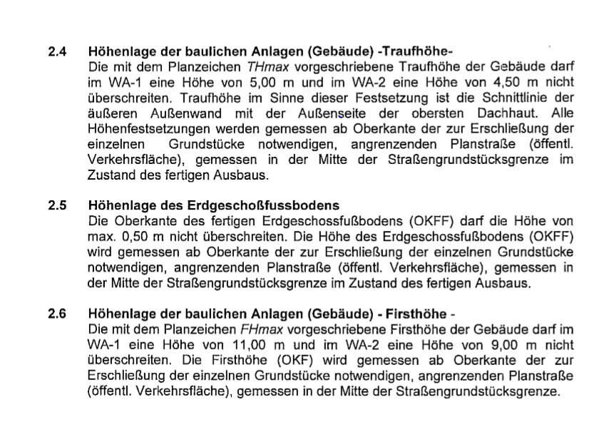
Eaves height = 4.5 m (15 feet)
Ridge height = 9 m (30 feet)
We would like to build a 1.5-story house with a gable facing the garden.
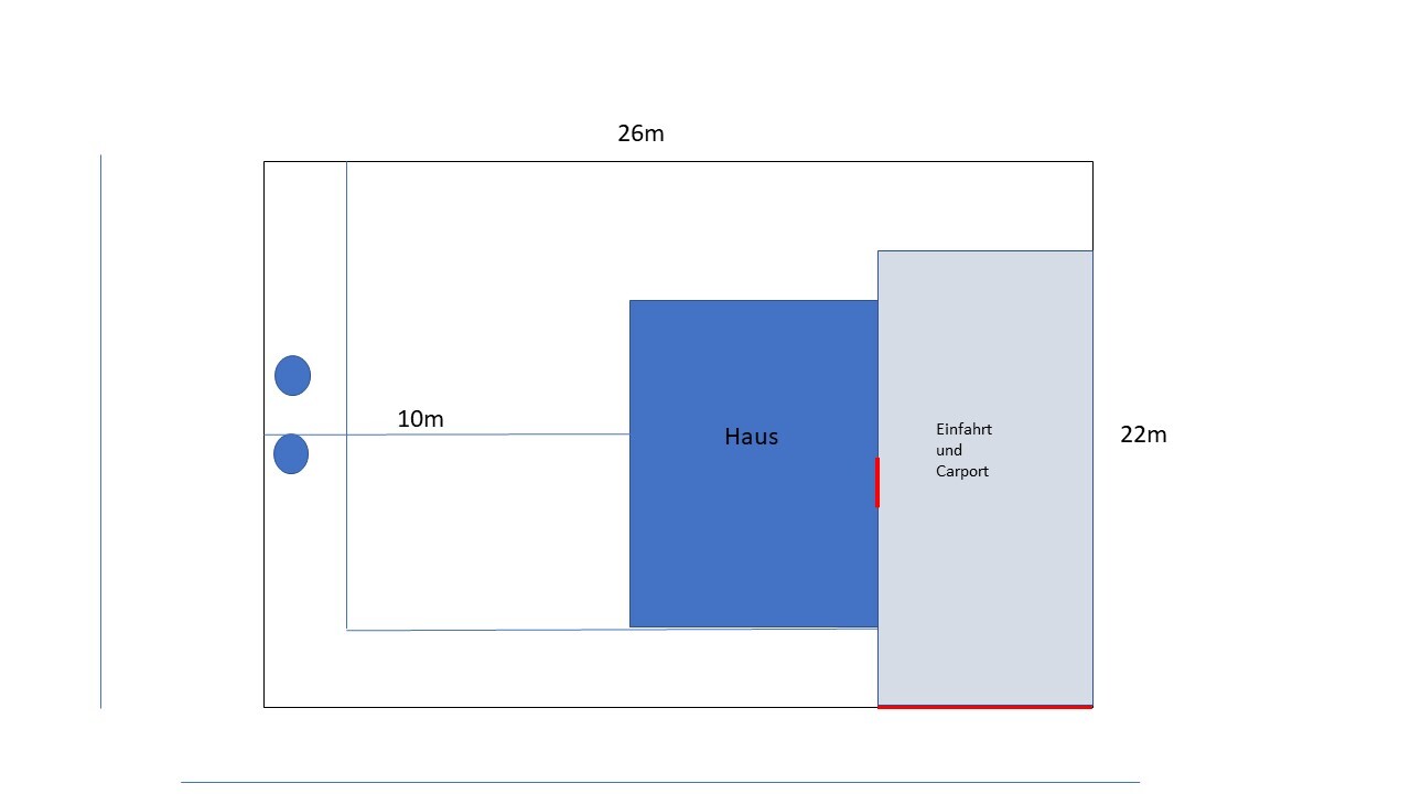
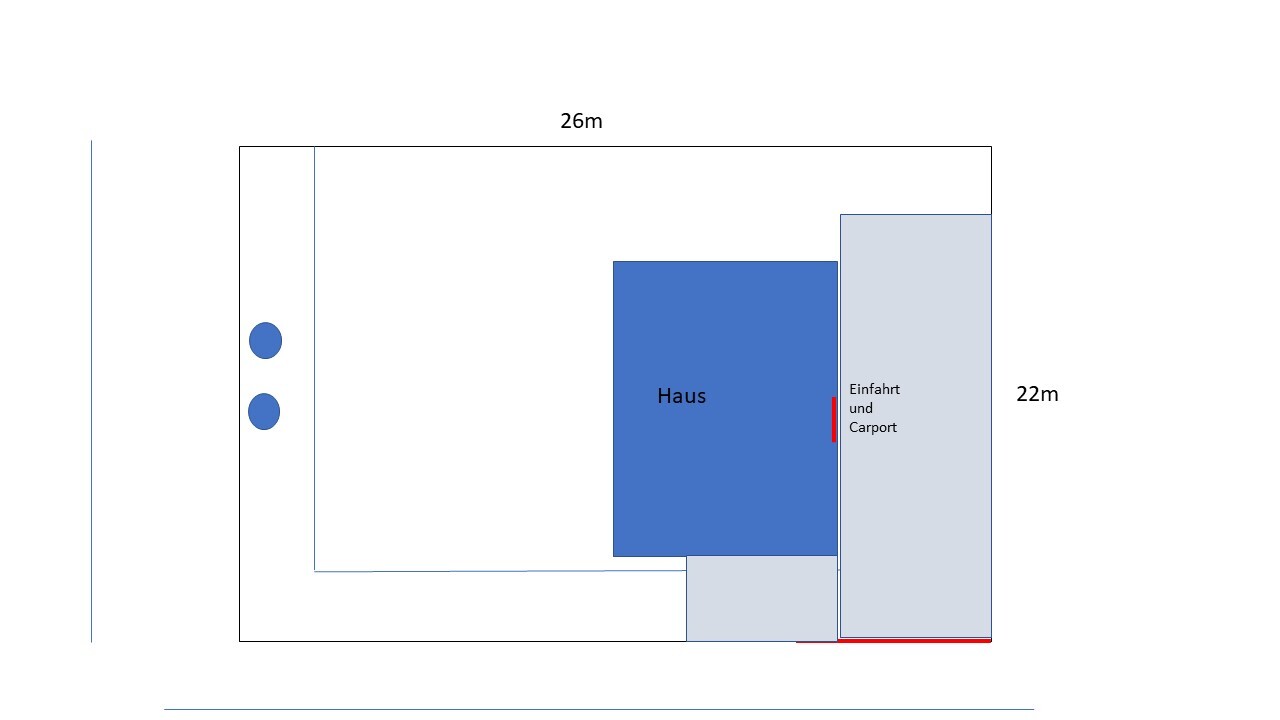
The driveway is planned on the longer street side. This means our driveway would be right next to the neighbor’s garden. However, the neighbor has raised their land much higher (above street level). Our entire lot is currently below street level. We would prefer to raise our land only up to street level and not higher. This is to avoid problems with the ridge height and to be able to position the house as close as possible to the street. On the other side, our other neighbor’s lot has not been raised at all and remains below street level like ours.
I have several questions:
1. Do you think it is a problem that the neighbor has raised their land so much while our driveway next to it will not be raised as high? The neighbor’s land is about 20 cm (8 inches) above street level, and our lot is currently about 70 cm (28 inches) below street level. We would build a concrete wall or something similar along our driveway.
2. The next issue is that our other neighbor’s land along the longer side toward the back is too low. Our lot is therefore between one that is raised and one that is lower. What should we consider in this case? This would basically mean our garden borders their yard.
3. Do you think the orientation of the house makes sense?
4. We are currently considering making the driveway wide enough for two cars side by side or narrower to have a larger garden and instead add a parking space in front of the house, lengthwise. I’m just not sure if parking there would always be practical.
Info about the pictures: The two circles mark the sewage and stormwater shafts.
We are currently planning to purchase a plot of land located in a new development area. It is a corner lot.
We are uncertain whether the lot can be built on well, and if so, how.
Floor area ratio = 0.3
Eaves height = 4.5 m (15 feet)
Ridge height = 9 m (30 feet)
We would like to build a 1.5-story house with a gable facing the garden.
The driveway is planned on the longer street side. This means our driveway would be right next to the neighbor’s garden. However, the neighbor has raised their land much higher (above street level). Our entire lot is currently below street level. We would prefer to raise our land only up to street level and not higher. This is to avoid problems with the ridge height and to be able to position the house as close as possible to the street. On the other side, our other neighbor’s lot has not been raised at all and remains below street level like ours.
I have several questions:
1. Do you think it is a problem that the neighbor has raised their land so much while our driveway next to it will not be raised as high? The neighbor’s land is about 20 cm (8 inches) above street level, and our lot is currently about 70 cm (28 inches) below street level. We would build a concrete wall or something similar along our driveway.
2. The next issue is that our other neighbor’s land along the longer side toward the back is too low. Our lot is therefore between one that is raised and one that is lower. What should we consider in this case? This would basically mean our garden borders their yard.
3. Do you think the orientation of the house makes sense?
4. We are currently considering making the driveway wide enough for two cars side by side or narrower to have a larger garden and instead add a parking space in front of the house, lengthwise. I’m just not sure if parking there would always be practical.
Info about the pictures: The two circles mark the sewage and stormwater shafts.
Toffifee88 schrieb:
That is all quite complicated. I never understand why it isn’t simply defined. Building code?
Toffifee88 schrieb:
How wide does such an embankment have to be? In our case, the development plan specified that it should not be higher than 50cm (about 20 inches), and no retaining walls like L-walls were allowed, only slopes up to 30 degrees were permitted. This meant, conversely, that with a height of 30cm (about 12 inches), the slope would extend 1 meter (about 3 feet 3 inches) horizontally. This ensures that no soil from your property simply falls onto the neighbor’s land. Many people just dealt with this by planting their hedge on a slightly sloped area.
T
Toffifee8810 Mar 2020 17:26ypg schrieb:
Building regulations?
In our case, the development plan specified a maximum height of 50cm (about 20 inches), I think, but no L-shaped retaining walls were allowed; instead, slopes with an incline of up to 30 degrees were permitted. This meant, in our case, that for a height of 30cm (about 12 inches), there had to be a slope of one meter (about 3 feet) in length. This easily ensures that no soil from our land would fall onto the neighbor’s property. Many people simply dealt with this by planting hedges on slightly sloped ground. Hmm, okay, I’ll have to read up on the building regulations again. Unfortunately, our development plan doesn’t provide any details. Otherwise, the building authority would probably provide information, right? Are those special bushes?
Neighbor B is actually responsible for the boundary fence around our property. But in this case, I guess we would have to take over.
T
Toffifee8810 Mar 2020 18:55I recalculated this again.
Assuming we fill the entire plot, which will probably be quite expensive since we cannot fill the whole plot with the excavated soil alone.
Assuming neighbor B stays as they currently are. Then the difference after our filling would be at most 80cm (31 inches) over a garden length of 7m (23 feet) from the house, so you could create a slight slope of 11°. Is 11° steep? Unfortunately, I have no idea how to assess that.
Thanks!
Toffifee88 schrieb:
Do you think it’s a problem that the neighbor has built up the land so much? If it were a problem, it would be for your neighbor. Anyone altering the terrain must ensure that no one is harmed.
Toffifee88 schrieb:
Do you think the orientation of the house makes sense? Yes.
Toffifee88 schrieb:
Or narrower? Yep.
Toffifee88 schrieb:
Just that you can’t go higher than 0.5m (1.6 ft) above the reference point. The reference point must be defined in the development plan (building permit / planning permission). Otherwise, it would be an indefinite condition, which could invalidate the plan. This kind of mistake doesn’t happen nowadays.
Toffifee88 schrieb:
I never understand why that isn’t simply fixed in advance. Then you’ll have to show us the development plan. Maybe we can explain it to you then.
Toffifee88 schrieb:
Unfortunately, our development plan doesn’t say anything about it. I don’t believe that.
Toffifee88 schrieb:
80cm (31.5 inches) over a garden length of 7m (23 ft) that’s 11% or about 6°. That’s quite steep. Accessible ramps are allowed a maximum slope of 6%. I would build a small retaining wall directly at the terrace.
T
Toffifee8811 Mar 2020 20:00Hello,
thank you very much for the replies and the drawing. I have a few more questions, which are listed below:
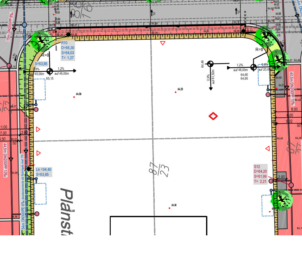
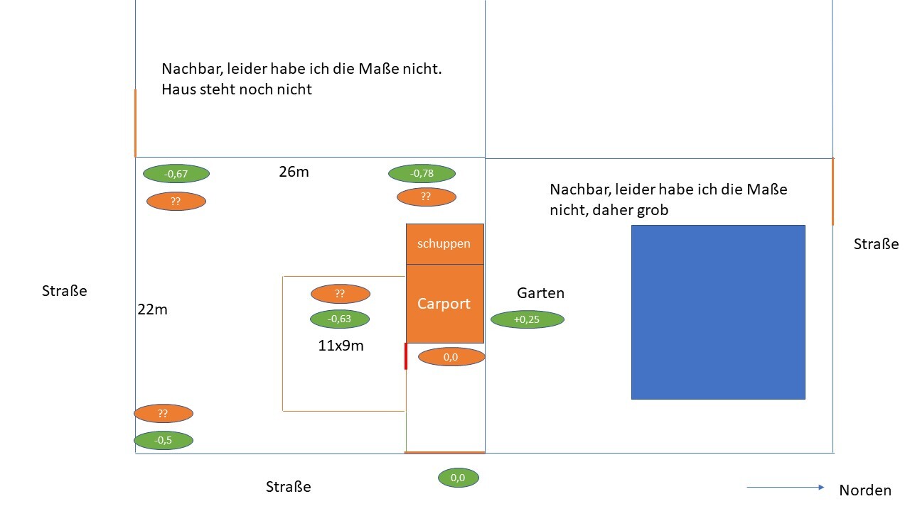
I have attached a few more files again. I have marked our plot on the site plan along with the utility lines. On the site plan, the values written in light print are the current ones, and the values written in bold are the planned ones.
We are orienting ourselves to the gray road, as the access is also shown there. Our builder has assumed this as level 0. Is it correct that we took level 0 here? The plot is a corner lot and has a slight slope. Or do we need to somehow take an average level?
What would be the optimal height setting for the house with the underside of the floor slab? We would leave the carport/courtyard at about 0 or raise it slightly towards the back to prevent water from standing in the courtyard. Could this cause any issues with the building authority if we fill the ground up that much? We actually only want to fill in as much as necessary under the house.
Our neighbor on the red road (visible in the photo bottom right) has a significantly lower level, also starting from his street. Since his driveway is on the red road, he will stay at that level. What is the best way to level out the elevation difference? How wide would a slope need to be towards his property to avoid problems? We would prefer not to install retaining walls. Especially at the rear corner of our plot, the elevation difference is quite large.
We will also need to slope the terrain towards the red road on our property. Here, we could either create a continuous slope or have a step down from the terrace to the garden, or are there other options?
The development plan only specifies information about eave height / ridge height and floor slab height (see attached). It states that the middle of the street should be taken as the reference height. Does this mean the middle of the gray road?
One more question about the utility plan: What does the black and white circle in the middle of the plot mean?
Plot ratio: The development plan only lists 0.3. Can we still use 0.45 for plot ratio 2? (Lower Saxony).
Thank you very much!!
thank you very much for the replies and the drawing. I have a few more questions, which are listed below:
I have attached a few more files again. I have marked our plot on the site plan along with the utility lines. On the site plan, the values written in light print are the current ones, and the values written in bold are the planned ones.
We are orienting ourselves to the gray road, as the access is also shown there. Our builder has assumed this as level 0. Is it correct that we took level 0 here? The plot is a corner lot and has a slight slope. Or do we need to somehow take an average level?
What would be the optimal height setting for the house with the underside of the floor slab? We would leave the carport/courtyard at about 0 or raise it slightly towards the back to prevent water from standing in the courtyard. Could this cause any issues with the building authority if we fill the ground up that much? We actually only want to fill in as much as necessary under the house.
Our neighbor on the red road (visible in the photo bottom right) has a significantly lower level, also starting from his street. Since his driveway is on the red road, he will stay at that level. What is the best way to level out the elevation difference? How wide would a slope need to be towards his property to avoid problems? We would prefer not to install retaining walls. Especially at the rear corner of our plot, the elevation difference is quite large.
We will also need to slope the terrain towards the red road on our property. Here, we could either create a continuous slope or have a step down from the terrace to the garden, or are there other options?
The development plan only specifies information about eave height / ridge height and floor slab height (see attached). It states that the middle of the street should be taken as the reference height. Does this mean the middle of the gray road?
One more question about the utility plan: What does the black and white circle in the middle of the plot mean?
Plot ratio: The development plan only lists 0.3. Can we still use 0.45 for plot ratio 2? (Lower Saxony).
Thank you very much!!
Toffifee88 schrieb:
Or do we somehow have to take an average value then? Yes, the "middle of the street property boundary." Gray: (65.00 + 64.77) / 2 = 64.89; Red: (64.48 + 64.60) / 2 = 64.54
Toffifee88 schrieb:
How should we ideally set the house height with the underside of the floor slab? The underside of the floor slab depends on the construction. The finished floor level must not exceed 64.89 + 0.50 = 65.39 if connected via the gray street, or 64.54 + 0.50 = 65.04 if connected via the red street.
Toffifee88 schrieb:
Could there be issues with the building authority if we raise the site that high? You would need to review the complete zoning plan including all textual regulations for that.
Toffifee88 schrieb:
Does that mean the middle of the gray street? "Middle of the street property boundary"; my interpretation: the middle of the property boundary adjacent to the street selected for site access.
Toffifee88 schrieb:
What does the black-and-white circle in the middle of the plot mean? Those are the gradient points for the drainage plan. Since your selection of the excerpt was very limited, I can’t explain further based on the drawing.
Toffifee88 schrieb:
The zoning plan only states 0.3. But can we still apply 0.45 for floor space ratio 2? Yes. However, if you continue to withhold the zoning plan from us, this remains speculation.
Similar topics