ᐅ Floor area ratio; Section 19, Paragraph 4 of the land use ordinance – Any experiences?
Created on: 29 Jun 2018 11:56
G
Garlintor
Hello,
I have a few questions regarding Section 19, Paragraph 4 of the Land Use Ordinance.
[Facts:]
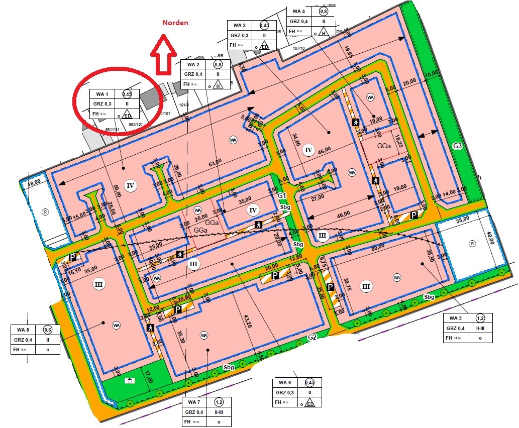
Plot size = 554.6 m² (5972 ft²)
Floor area ratio = 0.3
Buildable area = 166.38 m² (1792 ft²)
[My understanding of Section 19, Paragraph 4 of the Land Use Ordinance:]
Floor area ratio = 0.3 + 0.15 (50% of the specified floor area ratio) = 0.45
Buildable area = 249.57 m² (2686 ft²)
Is my understanding correct?
Which areas are included in this calculation?
Does Section 19, Paragraph 4 of the Land Use Ordinance have to be specifically mentioned in the zoning plan (building permit / planning permission) to be applied, or is it always applicable?
Or am I completely wrong?
Best regards


I have a few questions regarding Section 19, Paragraph 4 of the Land Use Ordinance.
[Facts:]
Plot size = 554.6 m² (5972 ft²)
Floor area ratio = 0.3
Buildable area = 166.38 m² (1792 ft²)
[My understanding of Section 19, Paragraph 4 of the Land Use Ordinance:]
Floor area ratio = 0.3 + 0.15 (50% of the specified floor area ratio) = 0.45
Buildable area = 249.57 m² (2686 ft²)
Is my understanding correct?
Which areas are included in this calculation?
Does Section 19, Paragraph 4 of the Land Use Ordinance have to be specifically mentioned in the zoning plan (building permit / planning permission) to be applied, or is it always applicable?
Or am I completely wrong?
Best regards
Incorrect. When a municipality designates a residential area, it must be treated as such. The municipality does not have unlimited discretion. QUOTE:
"Deviating provisions in the development plan (§ 19 paragraph 4 sentence 3 of the Building Use Ordinance)
The development plan can include provisions that deviate from the regulations of § 19 paragraph 4 sentence 2 of the Building Use Ordinance, for example, a higher or lower percentage rate, or a higher or lower limit than a floor space index of 0.8. The deviating provisions must be justified from an urban planning perspective...
Provisions must be made by text (§ 2); examples:
For the parcel of land ..... the specified floor space index of 0.3 may be exceeded by the floor space of structural facilities according to § 19 paragraph 4 sentence 1 of the Building Use Ordinance (note: date/source) up to a floor space index of 0.6.
The floor space of ... m² (… square feet) set for the parcel of land ..... may be exceeded by the floor space of structural facilities according to § 19 paragraph 4 sentence 1 of the Building Use Ordinance (note: date/source) by up to 120 percent."
The fact that the development plan in § 3(1) allows exceeding the floor area ratio for terraces and access paths COULD mean that these are not considered "privileged areas" under the provisions of § 19 of the Land Use Ordinance, and therefore technically belong to the main building, but a relief was intended for them. Thus, regarding area regulations, the development plan is actually less strict than the Land Use Ordinance. This would also make sense... rather smaller plots with denser development.

Denis L. schrieb:
The fact that the zoning plan in § 3(1) allows an exceedance of the floor area ratio for terraces and access paths COULD mean that these are not considered "privileged areas" under the regulation of § 19 of the Land Use Ordinance, therefore technically belonging to the main building, but an exception was intended for them. Be careful, you are mixing things up again: the access paths apply to the cul-de-sac lots in WA1, while the terraces are located in WA2 and WA4 (and here it is commendable that the zoning plan addresses this specifically, since opinions nationwide are not consistent on whether terraces belong to the main buildings or if they must be directly attached to these to be considered part of them).
https://www.instagram.com/11antgmxde/
https://www.linkedin.com/company/bauen-jetzt/
No, I already understood that different plots of land are meant each time.
The point is: I believe Section 3 provides *reliefs* for the *main buildings* limited by the floor area ratio: for some regarding terraces and for others regarding access paths. Especially in the latter case, this is quite fair, as otherwise the owner would be disproportionately affected by the shape and location of their plot. Assuming my understanding is correct, that both elements—terraces and access paths—are considered part of the *main building* in that federal state, meaning they are not classified as ancillary structures and therefore would not fall under the regulation of Section 19 (4). This section must also be applied additionally with the values specified in the land use ordinance.
Since I am not allowed to post links, there are guides for preparing building plans available on the websites of the cities of Hamburg and Munich, as well as from various law firms that offer courses on this topic. You can find these quickly through a web search.
At the end of the day, only the local authority or building department can give you a truly binding answer, and it’s best to have this clarified by an architect from the region. They have more authority and better knowledge of who can provide you with a reliable response (and they should be able to get one).
I had a similar issue and had to make several phone calls. The replies were politely worded but not very reassuring, such as, “I spoke with my colleague, it should be okay.” Any brief relief was soon replaced by shock when, at a second appointment with the architect, we were told that he believed it was actually NOT permitted. We then had it checked AGAIN through our architect, and it turned out it was allowed after all. Still, I’m already bracing myself for the wait after submitting the building permit/planning permission application.
That’s how variable the quality of development plans can be, unfortunately.
Oops, there are a few things that need clarifying here.
The basis for the calculation is the cadastral area recorded in the land register and noted for informational purposes in the land book. This is always given in whole square meters, so this cannot be the cadastral area. Otherwise, your calculation would be correct.
For main structures, plot ratio I: 555m² (5970 sq ft) * 0.3 = 166.5m² (1793 sq ft)
For all built structures, plot ratio II: 555m² (5970 sq ft) * 0.3 * 1.5 = 249.75m² (2687 sq ft)
If you fully use plot ratio I for the house and terrace, you still have 83.25m² (896 sq ft) left for garages, parking spaces, driveways, and secondary structures (garden shed, greenhouse, etc.).
The legal basis must be referenced somewhere in the documents, but not necessarily every paragraph. The Land Use Ordinance is federal law and therefore always applies regardless of the state building code. However, it allows the municipality some flexibility through §19 (4) sentence 3:
Different provisions may be made in the zoning plan departing from sentence 2.
The municipality exercised this option with §3 for your area WA1 under item 3. Specifically, this means you do not have to include the access path to your house in plot ratio I.
The original poster didn’t elaborate whether they actually intended to do such free summation. Here I find your comment more questionable:
This is debatable since we are dealing here with federal law and municipal ordinance, and the state itself has no authority in this regard.
Which is indeed a very important point.
This is precisely why the regulations of the Land Use Ordinance apply.
Exactly.
Yes, it does. The requirements for justifications have increased significantly in recent years.
Firstly, it does: the maximum framework would be 0.4, and secondly, it does not only apply the measurement of…
I agree with everything except the limitation to “state.” Regarding access paths, there is no clear consensus, so there remains interpretative flexibility.
Garlintor schrieb:
Plot = 554.6m² (5971 sq ft)
The basis for the calculation is the cadastral area recorded in the land register and noted for informational purposes in the land book. This is always given in whole square meters, so this cannot be the cadastral area. Otherwise, your calculation would be correct.
For main structures, plot ratio I: 555m² (5970 sq ft) * 0.3 = 166.5m² (1793 sq ft)
For all built structures, plot ratio II: 555m² (5970 sq ft) * 0.3 * 1.5 = 249.75m² (2687 sq ft)
If you fully use plot ratio I for the house and terrace, you still have 83.25m² (896 sq ft) left for garages, parking spaces, driveways, and secondary structures (garden shed, greenhouse, etc.).
Garlintor schrieb:
Does § 19 paragraph 4 of the Land Use Ordinance (Baunutzungsverordnung) have to be included in the zoning plan to be applicable, or does it always apply?
The legal basis must be referenced somewhere in the documents, but not necessarily every paragraph. The Land Use Ordinance is federal law and therefore always applies regardless of the state building code. However, it allows the municipality some flexibility through §19 (4) sentence 3:
Different provisions may be made in the zoning plan departing from sentence 2.
The municipality exercised this option with §3 for your area WA1 under item 3. Specifically, this means you do not have to include the access path to your house in plot ratio I.
11ant schrieb:
In this respect, your idea (of freely summing up areas) is indeed nonsense.
The original poster didn’t elaborate whether they actually intended to do such free summation. Here I find your comment more questionable:
11ant schrieb:
Depending on the state, roof overhangs, bay windows, etc. can also be included in the plot ratio.
This is debatable since we are dealing here with federal law and municipal ordinance, and the state itself has no authority in this regard.
11ant schrieb:
You also have to consider your floor area ratio of 0.45.
Which is indeed a very important point.
11ant schrieb:
This zoning plan ... does not mention any such second plot ratio
This is precisely why the regulations of the Land Use Ordinance apply.
Denis L. schrieb:
But shouldn’t the zoning plan explicitly limit the rules on garages that are contained in §19 (4) of the Land Use Ordinance under §3?
Exactly.
11ant schrieb:
The municipality does not have to justify its urban planning intentions.
Yes, it does. The requirements for justifications have increased significantly in recent years.
11ant schrieb:
It would not deviate from the maximum framework of the Land Use Ordinance
Firstly, it does: the maximum framework would be 0.4, and secondly, it does not only apply the measurement of…
Denis L. schrieb:
The point is: I think §3 creates *exemptions* for the *main buildings* limited by the plot ratio: for some regarding terraces and for some regarding access paths. Especially for the latter, this is very reasonable since otherwise the owner would be disproportionately affected by the shape and location of their plot. Assuming my assumption is correct that both elements, terraces and access paths, are counted as *main buildings* in that state and thus are not considered secondary structures subject to §19 (4). This regulation is additionally applicable with the values as stated in the Land Use Ordinance.
I agree with everything except the limitation to “state.” Regarding access paths, there is no clear consensus, so there remains interpretative flexibility.
Similar topics